Quantitative assessment of interrelations between groundwater withdrawal and land subsidence
In March 2008, Nesrin Tufekci started her PhD research at the Water resources section of Delft University of Technology. Her research, which is funded by the Turkish Higher Education Board, is focused on quantitative assessment of interrelations between groundwater withdrawal and land subsidence. The expectation is to use InSAR-derived distributed land subsidence measurements.
Introduction:
The increasing demand of groundwater at populated areas with arid environments leads to overexploitation of groundwater which leads to aquifer compaction and thus land subsidence in basins filled with unconsolidated alluvial, lacustrine, or shallow marine deposits. In recent years the advances in radar technology enabled detection of land subsidence at an average of monthly basis over a long time period. The application of InSAR, satellite differential synthetic aperture radar (SAR) interferometry, and persistent-scatterer (PSI) techniques to hydrogeologic studies has improved our capabilities to map, monitor, analyze, and simulate groundwater flow, aquifer-system compaction and land subsidence. In this context, the research aims to quantify and model groundwater level changes with respect to InSAR derived subsidence observations.
Research Objectives:
To develop a physically based quantitative model to monitor InSAR derived subsidence, related to groundwater removal.
- To test the model in areas having different geological, structural and climate conditions.
- To quantify historical groundwater use in basins where there is uncontrolled exploitation of groundwater by utilizing the information of aquifer response to groundwater withdrawal.
- To propose water management plan by defining aquifers vulnerable to subsidence and the factors of vulnerability.
- To assess optimal groundwater use for the areas geologically susceptible to subsidence.
Approach:
Construction of InSAR derived displacements considering the possible sources of errors. Identification of aquifer spatial heterogeneity and estimation of most significant aquifer parameters using Terzaghi’s consolidation theory. These parameters will be included in a subsidence and groundwater flow model for the construction of a physically based quantitative model. This model will express the interrelations between groundwater level changes and aquifer compaction, and assessment of unknown discharge of the past years.
Preliminary Results:
In order to study the relation between land subsidence and groundwater fluctuations five corner reflectors have been placed in the fields around the building of the faculty of Geodesy (Fig.1). These reflectors serve as permanent scatterers in an InSAR experiment monitoring the phase changes as a result of intentional displacements of the reflectors. To determine the height of the corner reflectors in an independent way, a precise leveling has been carried out from 2003 to 2008. Besides the leveling, the groundwater level has been measured in the wells near each corner reflector (from 2005 to 2008). The ground displacement at each reflector is calculated for five years and is compared to water level changes (Fig. 2). The measurements reveal that ground displacement follow the seasonal changes of groundwater level. Thus from these very preliminary results it can be deduced that these is a relation between the subsidence/expansion of land and groundwater level changes.
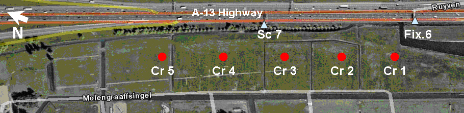
Figure 1: The location of corner reflectors.
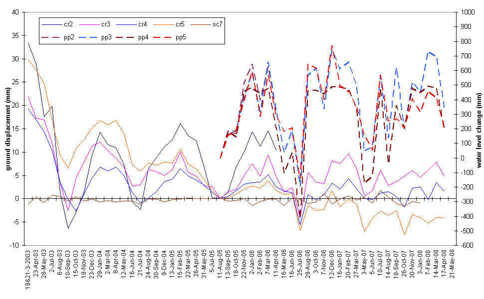
Figure 2: Ground displacement and water level change relative to fixed point and time
Scientific Relevance:
There are many studies in the literature on detecting land subsidence and aquifer compaction related to groundwater withdrawal. In these studies, aquifer parameters are derived based on Terzaghi’s consolidation theory. Model packages are developed to compute aquifer compaction depending on the groundwater level changes. This study will contribute by quantifying the groundwater withdrawal from the aquifer compaction based on a physical model. After the model is constructed and calibrated it will be possible to make predictions on historical groundwater withdrawal values which will be valuable information especially for areas with uncontrolled groundwater use.
Social Relevance:
The use of groundwater for irrigation has contributed significantly to ease the problem of hunger and of potable water supply to cities and rural areas. In arid or semi-arid regions the largest groundwater withdrawals are used for irrigation. The dependence on groundwater is expected to increase with increasing drought, which will lead to over exploitation and bring about problems like depletion of water levels, degradation of water quality, deterioration of aquatic ecosystems and land subsidence. Thus, assessment of optimum groundwater withdrawal is necessary for the solution of such problems and future water management.

Research Nesrin Tüfekçi
- +31 15 2789757
- N.Tufekci@tudelft.nl
-
Room number: Civil Engineering, 4.71