One portal for digital building permits. How?
The handling of building permits is often slow and opaque. A European project led by TU Delft geo-informatics should improve the process. 3D-Professor Jantien Stoter explains.
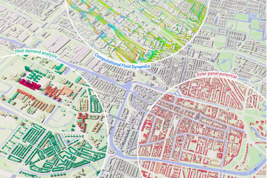
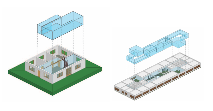
The way project leader Prof. Jantien Stoter (Faculty of Architecture and the Built Environment) explains it, the principle is very simple: an architect creates a digital design of a building in the form of a BIM (Building Information Model) file. The city where the building is planned has a three-dimensional geo-information system (GIS), which is a virtual twin city with information about the streets, buildings, trees, fire hydrants and so on. When applying for a building permit, a system automatically checks the BIM file for relevant building regulations such as whether the toilets are big enough or whether there are enough emergency exits.
In addition, the design is placed in the virtual twin city model to check its interaction with its surroundings. After all, regulations apply here too. What is the view and will the view of others be obstructed by the new building? How much sunlight will there be on the roof and façade? How will the design impact traffic noise? How far is the nearest fire hydrant? Digitising these checks can speed up the processing of building permit applications and make them more objective and transparent. That is the idea.
But as always, the devil is in the details, especially when the details concern a chain involving multiple disciplines: architects, geo-data specialists, construction companies, municipalities, software companies, standardisation organisations, and research institutes, representing 19 project partners from various European countries. Nevertheless, Stoter is confident that the Change Toolkit for Digital Building Permit (CHEK) project with its EUR 5 million budget over three years can make the future a little better for everyone involved. This Horizon Europe project started on 1 October 2022.
Is there a lot of interest in the project?
“Yes, very much. The Netherlands has the Environment Act (Omgevingswet), which was first introduced back in 2016 but which has not yet been passed. This is now scheduled for 1 January 2023. The Environment Act groups together 26 laws and regulations relating to the environment. The aim is that you only need to go to one desk, the Environment Desk, to apply for a building permit and everything will be checked there.”
Will the European CHEK project help in this?
“Definitely, because our challenge is integrating the BIM design into the urban planning context. Integration means that we can simulate the impact of the design on the environment, such as noise pollution, heat stress, and air pollution, and it will allow us to do things like a shade analysis of wind turbines. These disciplines work with 3D models and we work with them to find out what data they need. This helps us to automate the process. We also work on solutions for digital building permits, where one of the main bottlenecks is the integration between the BIM and GEO worlds. We have already done a lot of research on this and developed software for it.”
Is that why TU Delft is leading the project?
“The project builds on the results and findings of our previous projects. The TU Delft Innovation & Impact Centre coordinates the programme and does the administration. We coordinated the project proposal with Dr Francesca Noardo of our 3D Geo-information Research Group. Our group is also providing content project management to digitise regulatory checking. This starts by converting the regulations into a form that computers can work with. The necessary data – such as about floor geometry, housing units and building exteriors – is then deduced from the BIM design. That data is input in the 3D environment for the automatic checks.”
Surely with so many different groups involved, there must be conflicting interests. How do you deal with that?
“Geo-data is the domain of governments. It is their task to share information and develop and use open standards. The BIM world is more a world of industry and architects with business models and copyright interests that do not always benefit from sharing their data. Moreover, BIM models are primarily intended for design and construction - not as information source for other applications. That said, architects in particular have an interest in making the processing of building permits faster and more transparent. We therefore need to sit down with them to come up with data solutions that serve both worlds.”
The project will run for three years. What should be in place by then?
“Not all municipalities will have a fully digital check process by then, but we are developing tools for municipalities to digitally check regulations based on Geo and BIM files. This makes it easier for municipalities to start using the system and grow further.”
And does everything work digitally at the municipalities that are project partners?
“Yes, but at different levels and often semi-automatically. For example, we chose four municipalities of different sizes to work with. One is Ascoli-Piceno, a small municipality of 40,000-50,000 inhabitants in Italy; another is Vila Nova de Gaia, a medium-sized municipality in Portugal; and the last two are the large municipalities of Prague and Lisbon. We are working with them on a platform where the building permit applicant can see the status of the application in the procedure, what is being checked and what the outcome is.”
This starts to look like a single digital counter for building permits. The CHEK project plans to implement the one-stop building permit shop in four European cities in three years' time.
Header image: Samuel Regan-Asante via Unsplash
More information