Programme
Introduction to the programme
The core program of the MSc track Geoscience and Remote Sensing comprises generic courses on physics of the earth and atmosphere, geodesy and remote sensing, geo-data processing and analysis, and climate change. After the core program, the student can choose a personalized curriculum, with the opportunity to specialize for instance in environmental geodesy, surveying for civil engineering, or atmospheric sciences.
A study program in geosciences is not complete without fieldwork. Therefore you will participate in a 2-week fieldwork project, applying what you learned in the first year of the program. You will gain experience in the full chain from designing a measurement set-up, data acquisition and processing to understanding the (physical) processes of interest. In addition, you will become skilled to work effectively in a team and to manage a project. The fieldwork will be conducted on Iceland, in close collaboration with the University of Iceland.
Programme overview:
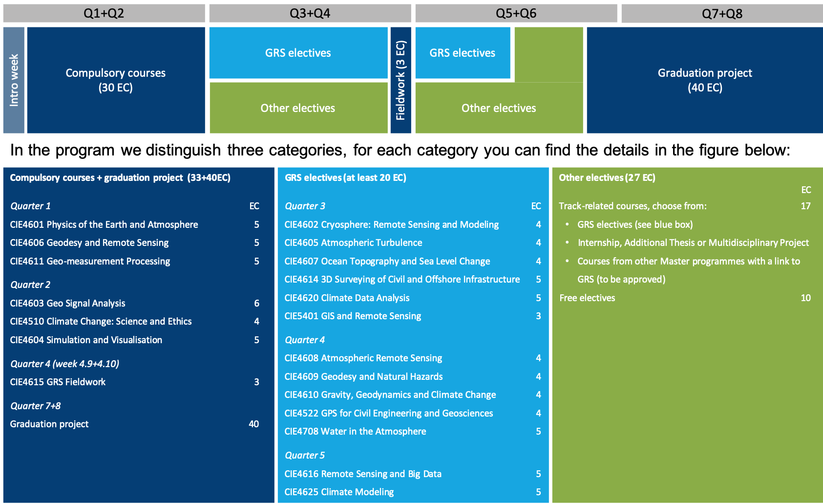
A detailed overview of the programme with course descriptions is available in this brochure.
The programme consists of six compulsory courses, offered in the first and second quarter. In the third and fourth quarter eight electives are offered, of which at least three (12 EC) need to be elected. In addition, you can choose other electives. The first year is then concluded with the fieldwork period in Iceland.
Discover various courses in detail, that are available in the MSc track Geoscience and Remote Sensing.
Using the course code, e.g. CIE4606, descriptions of the courses can be found in the TU Delft Study Guide, see www.studyguide.tudelft.nl
In the second year, there is the opportunity to follow more courses related to the field of geoscience and remote sensing, and there is room for some free electives (max. 10 EC). Furthermore, you can choose to use some of the elective space to do an internship or small research project.
Additional courses offered by GRS are:
- Journal club on climate change and Earth science (CIE5604, 3 EC) with annually changing topics, closely related to the research program of the department.
- Advanced project on Geoscience and Remote Sensing (CIE5603, 3 EC).
- GRS research seminar (CIE4612 and CIE5602, 1 EC) for which we invite international experts to present their latest results to our students and staff on a weekly basis.
Discover various courses in detail, that are available in the MSc track Geoscience and Remote Sensing.
Using the course code, e.g. CIE4606, descriptions of the courses can be found in the TU Delft Study Guide, see www.studyguide.tudelft.nl
The final part of the program is the MSc graduation project (40 EC). Examples of topics. Or have a look at the theses of our past graduates.
The Geoscience and Remote Sensing track does not offer specialisations with a fixed set of elective courses. However, you do have the flexibility to build your own ‘specialisation’, which are typically in line with our four scientific disciplines:
Atmospheric Science
If you are interested in studying physical processes in the atmosphere that have a strong impact on daily life, such as clouds, fog, precipitation, low-level winds, air quality, and more. You will learn about a large variety of observation and modeling tools, such as atmospheric profiling with radar, lidar and meteo towers, high resolution simulation and conceptual models. Atmospheric science provides crucial input for weather prediction, climate modelling and renewable energy development.
Earth System Science
You may also opt focusing on the system Earth and (some of) its four components: biosphere, hydrosphere, atmosphere and lithosphere. You will learn how to measure, model and interpret evolving physical properties of the Earth and with that shed light on the underlying processes and their impact, such as plate tectonics, volcanism, ice melting, sea level change, and surface deformation.
Geodesy
Monitoring planet Earth from a more geometrical perspective is what you will learn if you choose to specialise in geodesy. There is a wide range of applications, e.g. detecting how much ice sheets are melting, how vehicles move, or how infrastructure changes due to natural or man-made causes. The focus is on observation techniques, where space technology and working with big data play an important role. Geodesy is essential for all the engineering sciences (energy, infrastructure, transport, water, construction, security and safety), and many scientific disciplines (climate, environment, computational science).
Remote Sensing
In order to study the system Earth and its components we need remote sensing and in-situ measurements. Specialising in the remote sensing technology in terms of sensors (instruments), measurement principles and data analysis tools is another option you can choose for. Applications range from quantifying, explaining and predicting for instance sea level change, ice sheet and glacier change, hydrological cycle change, land use change, and surface deformation.