
Social Distancing Dashboard
Alessandro Bozzon, Achilleas Psyllidis
As countries take their first tentative steps towards loosening COVID-19 lockdown, society faces the difficult task of maintaining social distancing rules in practice. With growing numbers of pedestrians and cyclists returning to city streets, keeping a safe distance of 1.5m can be a challenge in many urban areas due to the way public space (or lack of it) has been designed.
The Social Distancing Dashboard creates interactive city maps that show on the level of streets and neighbourhoods whether social distance rules can be respected when moving in public space. It offers an overview of different factors – such as the width of the footpath and location of bus stops – that affect our ability to respect social distancing rules. In this way, it helps to raise awareness about constraints posed by the design of public space and contributes to decision making for COVID-19 related interventions in cities.
The dynamic and color-coded maps are open access and available for use by e.g. policymakers charged with making decisions on public health, and city planners tasked with making COVID-19 related interventions in the urban space. It is also intended to raise awareness amongst city residents – especially those in risk groups – who want to navigate the city streets as safely as possible.
High-resolution data
The dashboard fuses high-resolution data from the Basisregistratie Grootschalige Topografie, Statistics Netherlands (CBS), and OpenStreetMap to automatically estimate the width of footpaths and classify them according to a risk profile. The use of high-resolution datasets means that it is possible to perform analyses at different scales, ranging from postcode areas to neighbourhood, district, city, and regional levels – thus offering local as well as high-level insights into social distancing in a city setting.
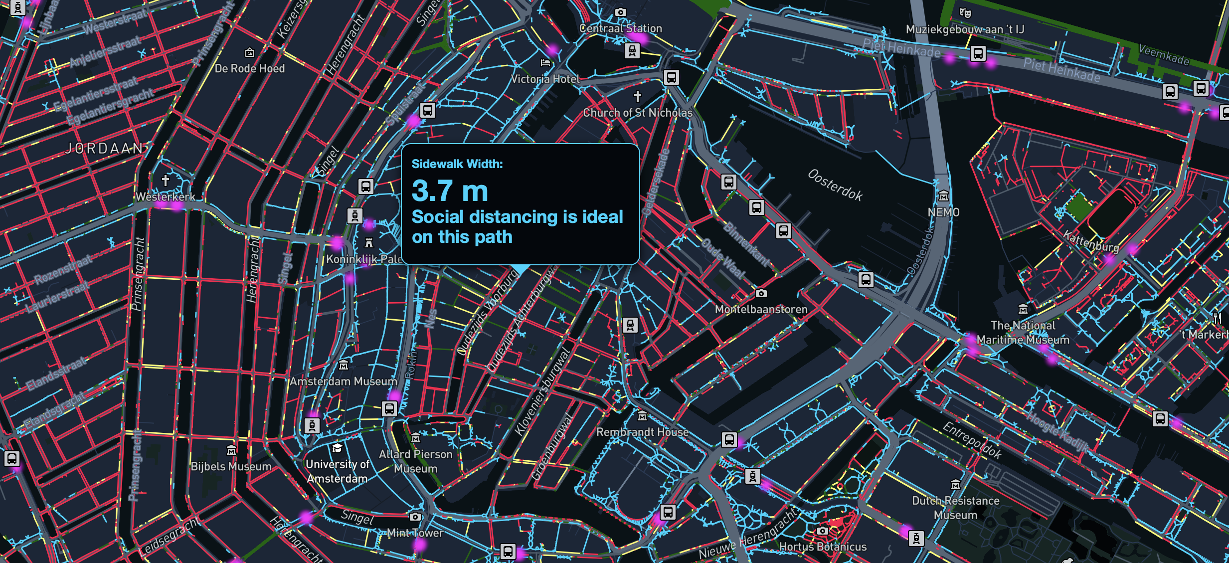
The goal of the Social Distancing Dashboard is to provide an overview of different aspects that affect the ability to respect social distancing in public spaces. It envisions to support policymakers towards designing successful interventions in the transition phase, which will be local in nature and could possibly relate to specific economic sectors and commercial activities.
The current dashboard includes information about the width of footpaths and public transport locations in various Dutch cities. As there are more factors that impact social distancing, additional information about other points of interest (e.g. facilities that attract many people, such as supermarkets, or other high traffic locations) and other types of data (e.g. mobility data, occupancy data etc.) will soon be included.
The Social Distancing Dashboard project is led by TU Delft’s Faculty of Industrial Design Engineering Assistant Professor and Research Fellow at AMS Institute, Dr. Achilleas Psyllidis, and a team of TU Delft researchers (Roos Teeuwen, Vasileios Milias, Carlo van der Valk, Shahin Sharifi, Sihang Qiu, Prof. Alessandro Bozzon, Prof. Gerd Kortuem).
Prof. dr. ir. Alessandro Bozzon
Alessandro Bozzon specialises in human-centred artificial intelligence (AI). Among other things, he looks at the information that is needed to predict and regulate e.g. crowds in the city. This expertise, as well as his experience in combining different data sources, he is now turning to help improve our insights into the spread of the coronavirus, and the local effects of different measures.
More information

Dr. Achilleas Psyllidis
Achilleas Psyllidis specialises in location intelligence and spatial analysis. He focuses on developing computational methods and location-based tools and services to help make sense of and characterise places and people’s activities, experiences, and interactions. Together with his colleagues, he develops tools to raise awareness about constraints posed by the design of public space and contributes to decision making for COVID-19 related interventions in the 1.5m society.
More information
SocialGlass
Social Distancing Dashboard
AMS Social Urban Data Lab
