
Tools to support social distancing
Serge Hoogendoorn
With contributions by Niels van Oort, Dorine Duives, Maria Salomons, Alexandra Gavriilidou, Winnie Daamen
Public transport is currently experiencing major problems: passenger numbers have fallen to only 10% and under current measures this could only be scaled up to about 40%. How to keep a distance of 1,5 metres at stations or stops, as well as in public transport vehicles, is still quite a challenge. Dutch Railways (Nederlandse Spoorwegen, or NS) are currently testing a corona-proof layout of trains and stations, so that passengers can travel safely and trains will become an attractive travel option once again. In buses, drivers no longer have to interact with passengers, but keeping the necessary distance between passengers is left to the passengers themselves. In line with other countries, it has now been decided that face masks will become compulsory for passengers and staff. However, managing the transport demand will remain necessary for the time being.
Managing supply and demand
In order to adapt mobility to a 1,5 metre society, we can try to influence demand, e.g. by spreading demand over time, dividing it over the various transport services, or reducing mobility as a whole. On the supply side, we can consider adapting services, networks and infrastructure, as well as regulating passenger flows. Solutions on both the demand or supply side can be based on voluntary measures such as informing, nudging, or rewarding passengers, or on mandatory measures such as compulsory reservations, the prohibition or restriction of activities or movements, or the closing off of certain areas or public spaces.
The extent to which businesses, attractions and educational institutions are reopening will play an important role as far as demand is concerned. Reopening already poses sufficient challenges to the locations in question, but transport to and fro could well prove to be a bottleneck. Interestingly, the crisis has increased options to travel outside of rush hours, or to avoid mobility altogether. Many people have by necessity become experts in working from home and home schooling. Recent data indicate that part of the population will continue to work from home even after the coronacrisis. In higher education, online morning lectures could lighten the load on rush hour public transport, but how will that affect students and lecturers?
Our travel behaviour after the coronacrisis is still uncertain. There are indications that people will avoid public transport, leading to more pedestrian and cycling traffic, but also to more motorised traffic. In China, traffic jams are already returning and even increasing when compared to just before the outbreak of the virus.
How can we model, predict and calibrate these developments with models and tools that were validated before the outbreak? A first step is to gain insight into future travel behaviour. Regardless of the solution, technology can play an important role: as a solution in itself, but also as a tool to design, evaluate and improve solutions.
Sensor technology can help
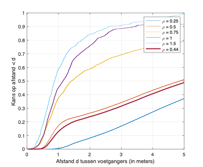
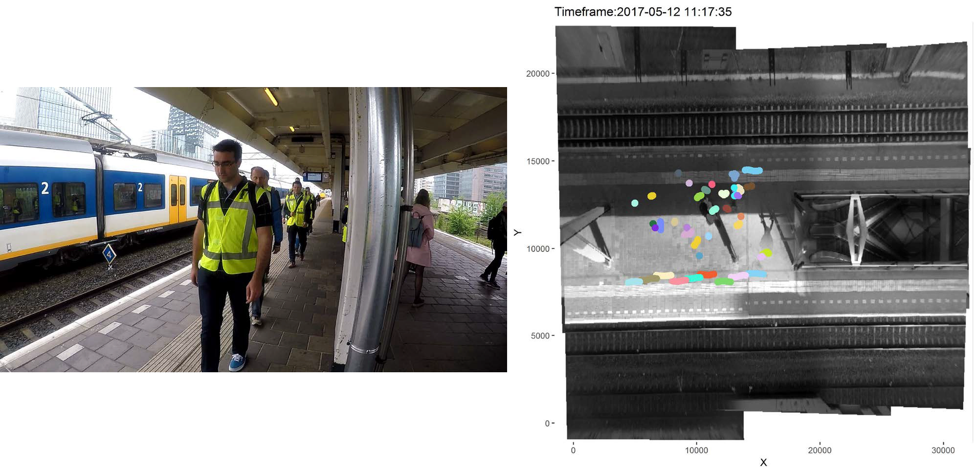
Sensor technology can support the design and evaluation of measures. Figure 1 below shows the distribution of distances between pedestrians as a function of the number of pedestrians per square meter over a day in May 2020. It shows the difficulty of keeping sufficient distance: at a density of about half a pedestrian per square meter, a distance of one and a half meters could no longer be maintained in 20% of cases.
Such insights can be obtained with advanced sensor technology and utilised to test or improve the effectiveness of solutions or to aid their development. An example are websites with forecasts on the busyness and the most recent data on road closures for popular destinations such as the beach, the supermarket or the garden centre. These offer potential visitors the opportunity to make alternative choices, e.g. for a different activity or location, or a different time of day.
When we return to a situation where the population gets more freedom, we will have to look for solutions to influence the demand for mobility. Rewarding people for working from home, or extra charges for non-crucial travel are some options here. Other possibilities are tradable mobility rights for non-crucial travel and reservation systems using Mobility as a Service.
Mobility as a Service
The MaaS (Mobility as a Service) concept is seen as the answer to the continuing growth in car driving, which has a major impact on the liveability of cities caused by, among other things, the amounts of space that cars occupy when they are not in use. MaaS provides a platform for various mobility services, enabling users to book their optimal combination of services, based on their personal finances and preferences, travel destination, etc. For example, taking an Uber to the train station, followed by a train journey and a rental bike for the last mile to your destination.
The MaaS concept also lends itself very well to the easing of the current crisis situation. MaaS can be used as a multimodal booking platform that takes the occupancy of the various services into account. For example, an option that includes a train that is already full, will not be offered, but passengers are given options to travel earlier or later, or use another mode of transport. Such a system can help ensure that the number of passengers wishing to use a public transport service at a given time does not exceed the number at which the minimum distance of 1.5 metres can no longer be achieved. In addition, it can also help to avoid disappointment among travellers.
In the example above, reservations are usually made under the 'first reserve, first serve' principle. The idea behind tradable mobility rights is that travellers can offer their reservation - their 'right' to make a certain multimodal trip - via an auction system to travellers who are willing to offer more to make that same trip at that particular time.
Normally, the aim is to maximise traffic flow, but he current situation is all about people being able to adhere to the 1.5 m distance rule. Technology can help here, e.g. by actively observing and predicting where and when a situation is about to become critical. Live alerts can enable organizations to solve potentially critical situations with minimal impact on passenger movements. This can be further supported by technology, for example by informing visitors who have yet to arrive, by smartly restricting the flow of visitors at entrances, or by dynamic route information systems
Controlling the use of infrastructure
Regulating demand is a good instrument for controlling the use of public transport. Managing the use of the available infrastructure for individual mobility requires different solutions. You only have to look at the many cyclists and pedestrians and users of rollerblades and other, new forms of mobility that have to share cycle and footpaths. This can be achieved by adapting the relevant traffic circulation plan with measures such as one-way traffic, explicit locations for queues, or increasing the available space for interactions. In addition to such static measures, a dynamic approach using traffic management can also contribute to the maximum use of popular pedestrian and cycle infrastructures.
Even if supply and demand are matched, small fluctuations in demand may lead to undesirable concentrations of passengers at different places in the mobility system, such as cyclists in front of a red traffic light, shoppers in front of a busy shop or commuters waiting for their train on a platform. All these accumulations of people pose a potential risk in the 1.5 metre society, but with dynamic management they can be kept to a minimum.
Here, too, technology can provide support. For example, a smartphone application for pedestrians or cyclists can inform traffic lights of their approach and thus prevent queues. Dynamic information systems such as Google can indicate busy places that are best avoided. Other examples include controlled bicycle parking at railway stations and a toilet waiting app for catering establishments.
Epidemiological risk profiles for different types of travellers can be used to prioritise modalities. For instance, a motorist in front of a traffic light runs less risk than a group of pedestrians.
Even when space is available, it will still be a challenge to actually keep a distance of 1.5 metres. Frequent reminders of the RIVM guidelines and small 'nudges' in the right direction may be necessary to allow people to maintain their distance. Here, static solutions may help, such as a circle with a radius of 1.5 meters drawn in the middle of a shopping street, or a double-sided arrow indicating 1.5 meters on a train platform or inside a train. Subtle dynamic reminders, called nudges, can also support us in maintaining the required physical distance. If we have data available on the positions of pedestrians or cyclists, we can, for example, use lasers to project a circle around a pedestrian, or make use of colour-changing street lighting. Dynamic information panels can display a smiley face or a warning if pedestrians or cyclists get too close to each other. Smart warning apps and bracelets could be a solution for schools.
In short, there are quite a lot of digital and other instruments to help maintain the necessary physical distance between travellers as well as can be achieved. A more systematic approach to travel and activities may be unavoidable. Real-time information about hustle and bustle, forecast dashboards and corona TripAdvisors could offer the public the opportunity to plan their activities with a view to the risk profile of these activities in time and space.
Prof.dr.ir. S.P. (Serge) Hoogendoorn
Serge Hoogendoorn specialises in traffic management. He focuses on observing, understanding and modelling traffic flows in networks. His main interest lies in the control principles needed to do this in the best possible way. Hoogendoorn and his colleagues are now using their knowledge and experience in this field to shape our mobility within the 1.5 metre society.
