
It is estimated that some 5.5 billion people will live in highly vulnerable climate regions by 2050. However, cities are grappling with ways to think and plan for a resilient future. To become resilient to extreme climate disruptions such as flooding and droughts, cities must transform long-term urban planning. With her advisors, Dr Nazli Aydin and Prof. Tina Comes, PhD candidate Supriya Krishnan is developing "The Future Ground": a methodology for long-term urban planning under climate change.
Fixed plans
Cities typically plan for 5 to 20 years, focusing on immediate development needs. So many infrastructure investments come together in a city - transport, energy, and water - that last for several decades. However, the underlying urban masterplan that ties different infrastructures together is too short-sighted.
"Planners are overwhelmed with day-to-day development problems. There is a housing crisis, insufficient drainage systems, building maintenance, and traffic management. They are in constant firefighting mode and work reactively instead of proactively. Hence innovation takes a back seat," says Krishnan. This is a critical problem because significant investments are made without sufficient foresight. These have negative consequences in the long run, such as attracting more settlements and industries to hazard-prone areas. Planning resilient cities of the future requires scientific evidence that can support long-term decision-making: think 40 to 100 years.
Visualizing risks and impact
Planning cities beyond 20 years is a methodological and procedural challenge. Despite the advances in quantitative methods and the availability of climate data, it is incredibly hard to think and model future urban growth. According to Krishnan practitioners mostly neglect the long-term impacts of their decisions as there is no clear methodology or business case for integrating long-term benefits into current decisions.
'The Future Ground' views climate resilience as a spatio-temporal challenge. "We use urban land-use simulations to visualize future growth and test the impacts of climate change. Visualizing risks on an actual map makes it much more thought-provoking than using only policy texts or charts". While practitioners may not be convinced 100% with the assumptions or consequences, the method is backed with sufficient scientific evidence to open up lines of thought which did not exist before. Not only is this a new approach to improving the perception of risk, but according to Krishnan, "the urgency is better felt because they can see the risk".

The methodology
In her research, Krishnan uses a combination of urban land-use simulations, exploratory modelling, and design thinking. "We want a spatial tool to inform which areas are most or least resilient to a specific risk and the type of urban projects suitable for these areas to minimize vulnerability." The final objective is to develop resilient planning pathways - a series of guidelines and evidence that planners can use to formulate forward-looking strategies to meet climate goals. "We want to emphasize the need for multiple urban growth trajectories to solve a city's problems and not be tied down by a single plan. With sufficient evidence, existing urban plans (or urban growth strategies) can become more flexible to accommodate changing insights. Planners need evidence, and with this innovative model, Krishnan is producing just that.
Case studies: Mumbai and Amsterdam
Another ambition of our work is to bridge the scientific knowledge divide in urban resilience between the Global North and South. The team aims to develop a robust methodology that can be adapted for data and institutional structures in different geographies. They use two cases as testbeds: the Metropolitan Region of Amsterdam (MRA) and the Mumbai Metropolitan Region (MMR). Both cases have different cultural and planning histories, complexity levels, and data availability. Nevertheless, both have strong ambitions to integrate climate goals into urban planning, which makes an interesting comparison.
From architecture to urban planning for climate risks
The choice for Mumbai, as a representative region for the Global South, was also made since Krishnan was born, raised, and received her undergraduate degree in the city. Later, she practised as an architect in the region. She has first-hand experience navigating urban flooding in Mumbai. "Wading through knee-deep water on the way back from schools and offices for a few days a year was very common." As a high-school student, during the 2005 Mumbai flooding deluge, she saw water enter her family's 'urban' apartment. "We temporarily moved upstairs to our neighbours' house, as we could not enter our own home." This experience drove her interest in urban risks and to actually do something about the city's urban issues.

Although she started her career as an architect, Krishnan wanted to focus on coastal cities and their risks. This led to a Masters in Urbanism at TU Delft, where she graduated from the Delta Urbanism group with a thesis on territorial planning for risks. This was crucial in understanding the fundamentals of planning under uncertainty, the concept of resilience, and sustainable design. The master strengthened her commitment to dive deeper into urban resilience, resulting in a PhD trajectory at the Resilience Lab at the Faculty of Technology, Policy, and Management. She is also being mentored as 1 of 25 next-generation women climate leaders for the city of Mumbai as part of the C40 Women4Climate program.
Reluctance to think long-term
The development of the land-use model was preceded by 39 formal long-format interviews with practitioners. Krishnan dove deeper into data requirements, planning processes, institutional procedures, knowledge gaps, and challenges in setting long-term climate goals while tackling planning challenges. Krishnan informally spoke to over 120 practitioners working in the Netherlands and India. "We wanted to combine expert's opinions of how to plan for climate change with robust information from the scientific literature." A preprint version of the theory building and analysis of the interviews can be accessed here.
Krishnan: "The current institutional structure makes it difficult to think on different spatial scales essential for a long-term strategy. In the case of Amsterdam, for instance, the city, the metropolitan region, the province, and national goals need to be considered and aligned. The same applies to Mumbai, where there is a disconnect between the city and the regional plan. A spatial approach at the national level, like the Delta plan Spatial Adaptation in the Netherlands, is crucial to guide the integration of climate goals in space. Another issue is that planning is fragmented into different domains and departments. Think of the landscape architect and urban planner, who use different methods and scales to solve the same problem. Strong knowledge leadership is necessary to overcome this issue."
Lack of urgency to consider climate change
The most significant barrier is that the urgency of planning for climate change is not felt in both Amsterdam and Mumbai. The focus is on building tens of thousands of homes. Whether or not they are built in a vulnerable region is not seen as a problem today. "Failure of flood defence infrastructure is perceived to be impossible in the Netherlands, though we see higher and higher incidences of flooding. Houses continue to be built in potentially dangerous areas. At the same time, planners state that the region prioritizes safety, flexibility, resilience, and sustainability. There is a mismatch here”, says Krishnan.
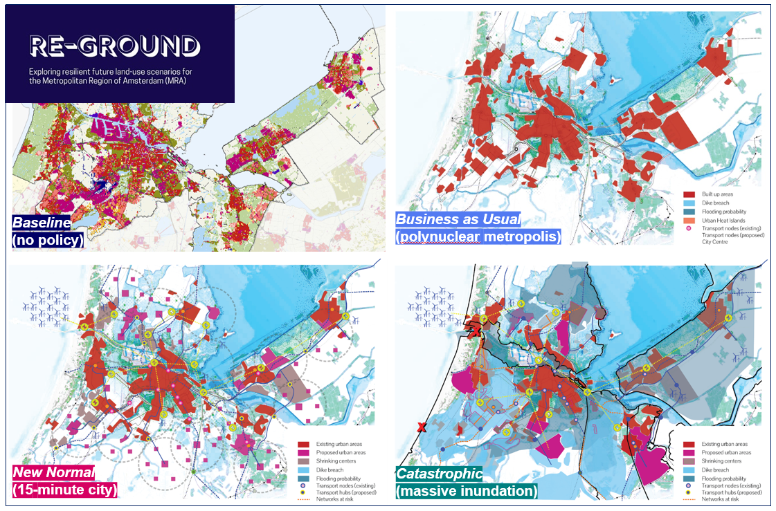
‘Re-Ground’: exploring resilient land-use scenarios for the MRA
Krishnan and the team conducted an experts consultation with practitioners from the Metropolitan Region of Amsterdam (MRA), the City of Amsterdam, PBL, VU Amsterdam, Hoogheemraadschap Rijnland, and Royal Haskoning DHV. They presented a demo of the urban land-use simulation, where practitioners could put forth their views on urban growth for the MRA and reflect on four imaginary future scenarios. The scenarios provoked discussions on what is desirable and what is not. What happens during a dike breach? Which roads need to be kept free of flooding? How do different functions like housing, commercial and green facilities behave? How do new concepts like 15-minute or walkable cities impact the urban fabric? The results from the consultation are being quantified and re-modelled as future development alternatives for the MRA. Krishnan: "For each scenario, we integrate risks from flooding, drought, and soil subsidence with policies to adapt or mitigate the impacts."
The first step is the hardest - changing perceptions about planning under climate uncertainties, as there are no immediate returns on investment. However, all infrastructure we plan and invest in today will face a climate future that they are not designed for. Hence, presenting robust spatial scientific evidence will help, and planners are interested. It is tough, however, to change a deeply ingrained preference for short-term planning, says Krishnan. "We would be happy if this methodology steers the mind-set of planners to think beyond immediate impacts."
Long-term resilience pathways
The team has a two-fold ambition to maximize research impact. First, Krishnan would like to co-create and reflect on the complexity of future urban scenarios with experts from other disciplines working on cities. A transdisciplinary approach is crucial in making such complex methodologies useful for decision-making. Second, Krishnan would like to take the methodology into the real world and understand its usefulness in planning processes in partnership with municipalities or metropolitan planning agencies. "We would like to develop concrete guidelines for cities to make the first steps to formulate long-term resilience strategies. We call this a long-term resilience pathway." This would be especially useful for cities of the Global South that are beginning to devise climate action plans and have the opportunity to invest in future infrastructure. In developed regions, such a method becomes helpful to consolidate and streamline investments for redevelopment and renewal in a sustainable way. Krishnan: "Much is being discussed in scientific literature, especially in uncertainties, risks, and forecasting, but not so much on the spatial planning aspect which ties everything together." This is also the innovation of this research. So far, Krishnan has noticed that people are interested in hearing more about their work and are supporting the research. "This is very encouraging, and we hope it will pave the way to scale up the research and find collaborations in more cities."
Publication mentioned
Articles:
- Bouncing Forward: Long-Term Urban Planning Under Climate Uncertainty
- Planning Support Systems for Long-Term Climate Resilience: A Critical Review
Websites:


