Ondergrondse infrastructuur
Intelligent use of subsurface infrastructure for surface quality
The subsurface is the technical space, the engine room of a city, housing the vital functions of water, electricity, sewers and drainage, but also housing the natural system that is crucial for a stable, green, healthy and livable city. Especially the effects of climate change, the boosts for an energy transition and the fact that there are less financial mean makes the intelligent use of the subsurface more important.
Situated in the DIMI theme safe, sustainable deltas and metropolises with the connecting theme of resilient, durable infrastructure this project focuses on the urban renewal of (delta) metropolises. The main question is how to design resilient, durable (subsurface) infrastructure in urban renewal projects using parameters of the natural system – linking in an efficient way (a) water cycle, (b) soil and subsurface conditions, (c) soil improvement technology, and (d) opportunities in urban renewal (e.g. urban growth or shrinkage)
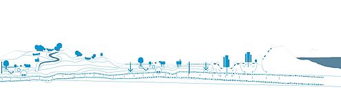
By understanding and re-designing the engine room we aim for a more efficient overall system (starting from the subsurface and reflecting on the surface level). Moreover, the subsurface is a crowded place and without planning it there is no room to make use of novel solutions that the subsurface can offer cities for managing water, heat and renewable energy or underground space more efficiently.
The project was developed in two phases, the first phase concentrated on synchronization of the connected disciplines: water management, geo engineering and urbanism. The second phase was focused on the architectural representation of the subsurface in cooperation with the municipality of Rotterdam and Leiden.


Phase 1: Synchronization
The first phase was taking an explorative method tackling the question “how can the different technological artefacts in the subsurface be synchronized offering more space and adding to a better urban quality?” Explorative research has been useful in studying wicked problems, problems that have not been clearly defined. The exploration was framed by co-creation in workshops and later a more precise elaboration of these results in the working group. The three main methods that build the framework are: Forecasting, backtracking and backcasting (Van de Dobbelsteen et al., 2006), Visualization and Vision making with adaptive pathways. As an outcome, by applying this framework, the direct relation between technology in the subsurface and the design of public space and urban main structures in urban development was made clear between the pool of participants in this project. In particular, the focus was placed on potential future synergies between technologies and their contribution to urban quality. This is the start of a working method that could include more technologies and a further elaboration of the visualization of the surface and subsurface as one united space.
Phase 2: Architectural representation
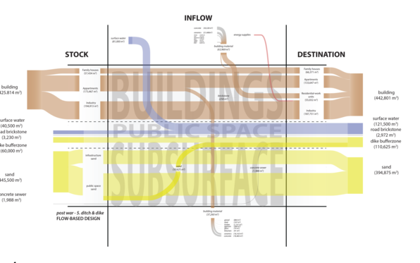
This phase builds on a former project of TU Delft and Deltares (2010) Design with the Subsurface, in which the System Exploration Environment and Subsurface (SEES) and the Subsurface Potential Map were developed. The SEES is a system overview in which the domains involved in urban development are mapped out. Each domain has its own specific specialists, concepts and language that for true interdisciplinary working need to be recognized. The Subsurface Potential Map is a map in which the data has been translated into information of the subsurface artefacts in the categories of civil constructions, water, energy and soil / ecology.
During this phase the potential map is refined and contextualized to a Technical Profile in which more scales are represented with a shared precise legend that has solid and process items. The explorative method of this project brought forward insights and design methods for the urban renewal of (delta) metropolises where resilient, durable (subsurface) infrastructure is carefully balanced out with parameters of the natural system.
The challenge is to draw all the different artefacts in such a way that relationships between them and the surface artefacts become insightful and thus enable decision making about the desired interventions and effects. In addition, some artefact also affects the higher scale, such as water, energy and ecology, and others, such as cables and pipes and ecology also need to be represented on the small scale of a street section. The drawing of the subsurface, or the Technical Profile, is tested in Rotterdam and Leiden by organizing workshops to make an inventory of the data and generate clear sight on the applicability of new technologies. The first workshop is structured by using the SEES and had the purpose to collect relevant data and create base for understanding disciplinary perspectives. The second workshop consisted of responding to provocative scenarios in multidisciplinary groups to create interdisciplinary design thinking in which potential future synergies and cascading relations between technologies also aim at a contribution to urban quality.
Rotterdam
Bloemhof-Zuid is an urban district built in the 1930s on a very wet and soft terrain with ongoing subsidence. In the middle houses are built on slabs and along the borders on wooden bearing piles. This makes the groundwater level management extremely complicated and, as a solution, the owner of most of the houses on slabs, the housing corporation Woonstad, has placed water pumps in a number of places to prevent flooding. Furthermore, the technical state of the houses is not future-proof and the urban structure does also not fit the modern requirements (narrow streets, little parking spaces, green spaces and play grounds, and shallow lots).
The question is how the real estate can be developed in the long term, considering the subsidence. To this end, the municipality of Rotterdam and Woonstad are making a vision in which the technical condition, or the technical profile of the district, plays an important role.
Link report
Leiden
The question for the Leiden central station area is how innovative technologies can be utilised to support the energy transition, adaptation to the changing hydrological cycle and increase in bio diversity in the region of Leiden, Katwijk, Oestgeest, Leiderdorp, Voorschoten and Zoeterwoude? In the project an inventory is done to see how innovative technology could fit into the current urban construction and systems of the Leiden central station area, where cascading effects could be positively utilized.
Link report
Results
Hooimeijer FL and Lafleur F (eds.) (2018) Intelligent SubSurface Quality 004 Drawing the subsurface:
Integrated Infrastructure and Environment Design. Delft: University of Technology.
See this link
F.L. Hooimeijer, F. Lafleur, T.T. Trinh (2017) Drawing the subsurface: an integrative design approach. Procedia Engineering Volume 209, 2017, Pages 61–74
See: https://doi.org/10.1016/j.proeng.2017.11.131
Hooimeijer, F.L. (2017) Ontwerpen met bodemdaling in de stad.
See:: http://waterviewer.tudelft.nl/#/ontwerpen-met-bodemdaling-in-de-stad-1497346936351
and https://www.gebiedsontwikkeling.nu/artikelen/ontwerpen-met-bodemdaling-de-stad/
Hooimeijer FL, Kuchincow Bacchin T and Lafleur F (eds.) (2016) Intelligent SUBsurface Quality 001: Intelligent use of subsurface infrastructure for surface quality. Delft: University of Technology. See: https://pure.tudelft.nl/portal/en/publications/intelligent-subsurface-quality(6eff83a8-d0c6-438e-aa42-0dbd03835ac9).html
Hooimeijer FL and Lafleur F (eds.) (2017) Intelligent SubSurface Quality 002 Leiden Stationsgebied. Tabula scripta: Structureren, visualiseren en presenteren. Delft: University of Technology.
See: https://repository.tudelft.nl/islandora/object/uuid%3Aebeded93-0cdb-4793-a5c2-c49ff2652fda?collection=research
Hooimeijer FL and Lafleur F (eds.) (2017) Intelligent SubSurface Quality 003 Rotterdam Bloemhof-Zuid. Tabula scripta: Structureren, visualiseren en presenteren. Delft: University of Technology.
See: https://repository.tudelft.nl/islandora/object/uuid%3A8b75ee3f-3b1b-4536-a152-87a5caafcff0?collection=research