Space Instrumentation
Space instrumentation (systems) engineering covers a key research topic within the chair Space Systems Engineering and beyond. Strong research ties are present within the department Space Engineering as a whole as well as with diverse other faculties within the TU Delft, i.e., TNW, EWI, CiTG and ME. Furthermore a strong corporation with the Dutch high tech space scene is present through companies and institutes such as: Airbus Defence Systems (ADS) Leiden, COSINE, ISIS, TNO Space, Lens R&D, SRON, ASTRON, RUL, TUT, TU/e and the recently constituted Delft Optics Centre (DOC). The Space Engineering department is well recognized for its work on the design, development and launch of educational nano-satellites. The study and development of small space instruments and sensor system for this class of small satellites (CubeSats, PicoSats) is one of the most important short-medium term objectives in our current roadmap.
These instruments provide with Earth Observation (EO) data which has become more and more important for a wide variety of applications. High-Resolution EO ranges from defence and security to environmental monitoring, precision farming and disaster response. This data is presently captured by EO systems such as GeoEye, Quickbird, Worldview, Spot and Planet-Labs. Such satellites, except for Planet-Labs, are large, heavy and expensive. As a result, data produced by these satellite systems is also very expensive. Moreover, the number of systems capable of capturing imagery at a high resolution is still limited whilst the swath width of these systems is typically small. This means that for many regions on Earth, frequently updated imagery is simply not available.
The market for CubeSats offers a huge potential for Earth Observation (EO) satellites with a high re-visit time. However, the development to sustain a higher spatial resolution better than 4 m is a challenge. It requires a stable EO platform to acquire accurate EO images from Very Low Earth Orbits (VLEO) in the altitude range 230 – 380 km. To obtain a pointing accuracy down to 1 degree and a high stability of the spacecraft, severe difficulties are present due to the nature of the atmosphere at these altitudes. The thermosphere is affected by the solar flux and magnetic indices which impose significant temperature and density fluctuations. The control of these issues, combined with free molecular flows, requires a complex model to predict any disturbance to be encountered.
The current research is focussing on the following topics:
-
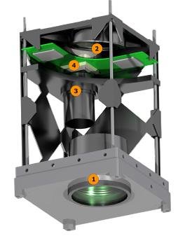
Small instruments and sensor development for PQ’s and CubeSats. Fig-1 shows the ANT-1 camera which was developed as a phase-A concept in the chair SSE. A lens-less camera, being a new research area, can serve as a PQ optical payload. The research towards its realization is done in corporation with the faculty TNW.
-
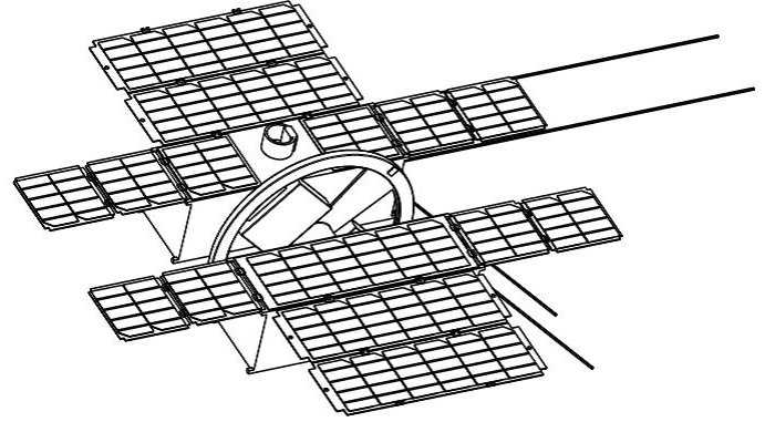
Stable Highly Accurate Pointing EO (SHAPE) 6U CubeSat design. This novel CubeSat design concept can in principle yield an exceptionally stable satellite for high-resolution VLEO EO. SHAPE uses the principle of momentum conservation by integrating a large momentum wheel in the centre of the spacecraft composed of two 3-unit CubeSats. Its rotational speed is increased up to 7000 rpm to ensure that external disturbance torques are effectively counteracted. It was sized on the largest (aerodynamic) disturbance yielding a design torque of 0.014 Nm, 0.469 kg mass , 15 cm radius and 1 cm thickness. A resisto jet developed at the TU Delft is used to accelerate the wheel to the high speed. Additional power is delivered by a battery inside the wheel, adding required mass as well. To ensure stability, dedicated liquid dampers can be designed to attenuate additional vibrations and residual nutation. Momentum and reaction wheels are commonly used in satellites. Literature shows that this is the first application of a substantial momentum wheel using a novel type of a magnetic bearing in a VLEO NanoSat. SHAPE provides with an innovative, out of the box, and simple solution, by tackling the problems of instability of EO from a VLEO spacecraft. Its costs are very competitive, roughly estimated 400 k€ for the platform, including a dedicated optimised camera concept version of the ANT-2A Cubesat camera developed earlier by the TU Delft. However, a variety of cameras can be used, inexpensively and efficiently, with this platform using a standard plug & play interface. The momentum wheel plays the dominant role in stabilising the platform, using a simple, trusted, reliable and efficient method. Currently an MSc student is working on the refinements of the ADCS design, especially the options to stabilize the momentum bias wheel in the attitude acquisition phase.
-
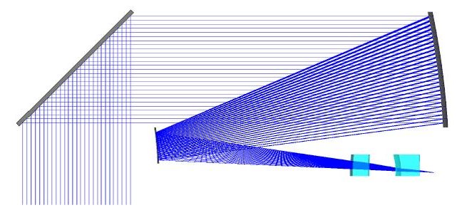
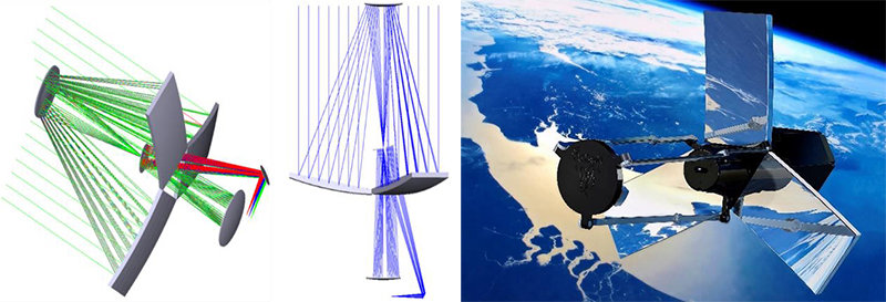
Deployable optics have the potential of revolutionizing the field of high resolution Earth Observation. By offering the same resolutions as a conventional telescope, while using a much smaller launch volume and mass, the costs of high resolution image data can be brought down drastically. In addition, the technology will ultimately enable resolutions that are currently unattainable due to limitations imposed by the size of launcher fairings. To explore the possibilities and system complexities of a deployable telescope, a concept study was done to design a competitive deployable imager. The concept of a Deployable Space Telescope (DST) is a key part of research with goal to obtain a ground sampling distance of 25 cm from an orbital altitude of 550 km. It offers an angular field of view of 0.6° and has a panchromatic channel as well as four multispectral bands in the visible and near infrared spectrum. The segmented primary mirror consists of four tapered aperture segments, which can be folded down during launch, while the secondary mirror is mounted on a deployable boom. In its stowed configuration, the telescope fits within a quarter of the volume of a conventional telescope reaching the same resolution. A joint TU Delft and ADS Leiden team is working on a first breadboard demonstrator project to be launch on the VEGA launcher in two years. The project is supported by ESA, TNO Space, ADS Leiden and multiple faculties within the TU Delft.
-
In a strong coporation with TNO Space the mission and ADCS design of a new generation of small optical payloads like Spectrolite, Tropolite is being developed. Tropolite is the small scale version of the famous Dutch Tropolite instrument. Two MSc students are currently doing their thesis work in this research field.
-
A Cube-Sat camera cornerstone design for a multiple aperture earth observation system, Kuiper, J.M. & Bouwmeester J., Proc. of the 62nd IAC, pp. 1-8, Cape Town, 2011
Cube-sat constellation designs for EO systems, Kuiper, J.M. & Dolkens, D., R. Sandau (ed.), Proc. of the 9th IAA Symposium on Small Satellites for Earth Observation (pp. 1-4). Berlin: DLR, 2013
H. Klinkrad and B. Fritsche, Orbit and attitude perturbations due to aerodynamics and radiation pressure, in ESA Workshop on Space Weather, ESTEC, Noordwijk, Netherlands, 1998.
E. Doornbos, Thermospheric density and wind determination from satellite dynamics, Springer Science & Business Media, 2012
H. Kuiper and E. Bongers, Flight nutation validation of the COS-B and Equator Spacecraft, Advances in Aerospace Guidance, Navigation and Control, pp. 721–740, Springer, 2013
K. Anflo, T.A Groenland, G. Bergman, M. Johansson, and R. Nedar, Towards Green propulsion for Spacecraft with ADN-based Monopropellants, 38th AIAA Joint Propulsion Conference, AIAA Paper, vol. 3847, p. 2002, 2002.
T. V. Mathew, B. T. C. Zandbergen, M. Mihailovic, J. F. Creemer, and P. M. Sarro, A Silicon-Based Mems Resistojet for Propelling CubeSats
Dolkens, D. and J.M. Kuiper, A Deployable Telescope For Sub-Meter Resolutions from MicroSatellite Platforms. International Conference on Space Optics 2014, Tenerife, 2014