
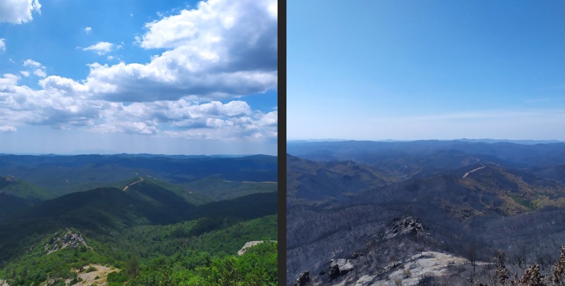
Many Mediterranean countries suffer destructive and even deadly fires every year. For example, in August 2023 Greece saw much of its native forests incinerated by the immensely destructive Dadia wildfires. How will we protect people, nature, and infrastructure? Konstantinos Karalidis, shortened to Kostas, used his MSc thesis at the Faculty of Architecture and the Built Environment to investigate the possibility of using AI-enhanced fire detection and prediction models. “This is something which can be done now, not some utopian vision.”
Kostas vividly remembers how in 2018 out of control fires in Greece shook the country to its core. In the Attica region more than 1500 homes were destroyed or damaged. That same year, the fire around Mati was the deadliest disaster since the second world war. Kostas: “How could this happen in these prosperous times?” When choosing his MSc thesis project, this Greek student decided to apply his programming skills to the problem of wildfires. “Deep learning and AI is now all around us. The breakthroughs in the past years are enormous.” Kostas is convinced that the immense potential of this technology requires immediate investment.
Detect and predict fires from satellite photos
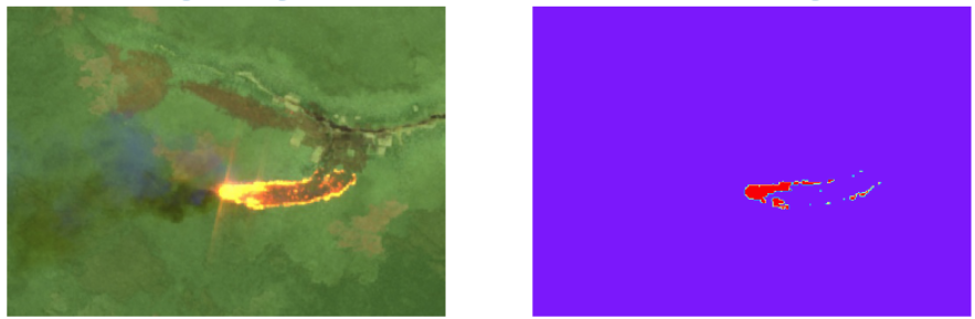
For the first part of his thesis, Kostas used Open-Source satellite images (sentinel-2) of areas suffering from wildfires. At first, the identification of fire and non-fire images was done manually. These pre-labelled images were used to train his model, which is where AI stepped in. It allowed using a smaller number of fire and non-fire images through iterative separation of the two types. The resulting model reached over 90% accuracy when separating new images with and without fire. Kostas then demonstrated that his model could detect fires in entire sections of the satellite data, a vital attribute when considering real-world application.

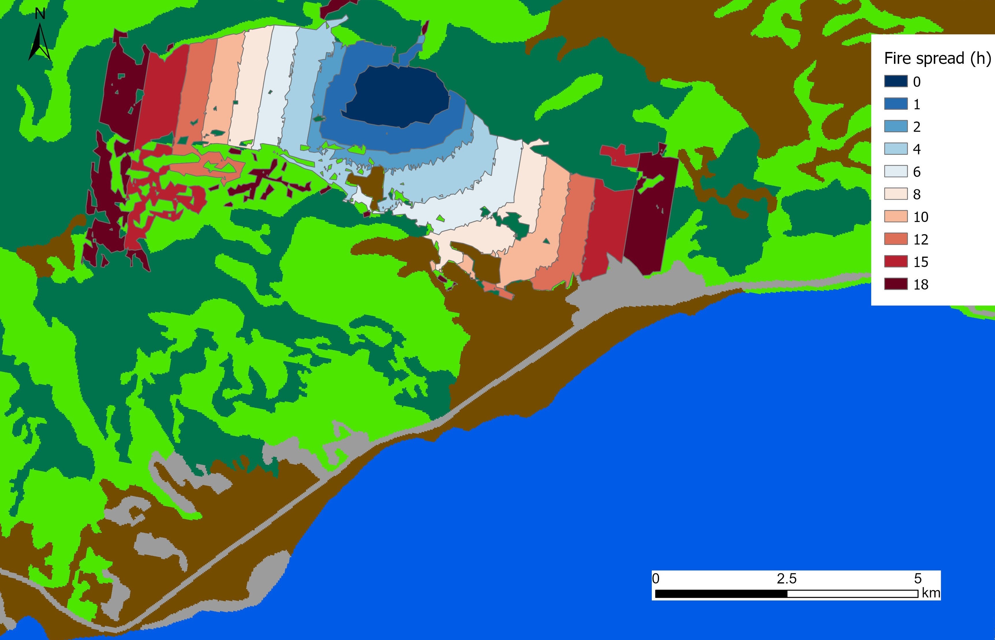
The second part of Kostas’ thesis used the same dataset to simulate wildfire progression. In other words, he aims to use algorithms to predict the future. The dataset was converted to cellular automata, meaning pixels with attached data points such as elevation, slope, wind speed, etcetera. The model uses all these values and feeds them into algorithms with ‘neighbourhood’ rules and transition rules to simulate the changing situation over time. In the case of a forest fire, the algorithms predict its spread. So how did the model fare? The prediction of which area would be burned was 62% accurate compared to the real data.
Improving digital models to save real-life people
Considering the limitations (exclusion of wind direction, wind speed, human intervention) 62% is actually quite successful. One major shortcoming in current predictive models is that, in real life, many factors such as wind speed and temperature change over time. “If you have AI, you can improve the model’s ability to predict these changing variables, especially wind.” Kostas estimates that if his model is equipped with better software, more complete datasets, and more powerful Artificial Intelligence, it could overtake the previous record of 90% accuracy. And there are further benefits to including AI. “Fire fighters and decision makers could include planned interventions into the model and get predictions of the effect. And AI models would also be better able to visualise the resulting predictions.”
Images from sentinel-2 are only updated once every six days, but there are companies with satellite data which update every thirty minutes and feature much higher spatial resolution. Kostas envisages using their data during the summer months to cover high-risk areas, which would enable rapid response to emerging fires. Either extinguish them within hours or evacuate the area. So, Kostas, what should the future of this project to look like? The answer is both complex and simple. Complex because “I want an automated system to detect fires in all high-risk regions in the Mediterranean. Satellite footage is analysed, predictions are generated, and a rapid response is set in motion.” But also simple, because ultimately, “I want these models to save lives.”
More information
Konstantinos Karalidis graduated from the master's programme Geographical Information Management and Applications (GIMA) and was supervised by prof.dr.ir. P.J.M. van Oosterom and dr. Azarakhsh Rafiee.


