Scanning grains of sand
TU Delft researchers are using scanners, current meters, drones and satellites to study beach and dune erosion and accumulation at Noordwijk aan Zee. Storm Ciara arrived right on time.
From one of the higher terraces at hotel Huis ter Duin, a laser scanner emits an endless series of invisible light pulses as it probes the coastline. This instrument is charting the height differences on the dunes and beach with centimetre precision.
Right next to it, a wind meter – a rotating anemometer – does pirouettes. “Earlier this month, we measured gusts of wind of 39 metres per seconds”, says Dr Sander Vos from the coastal engineering department (Civil Engineering and Geosciences/CEG). “That’s wind force 12.”
For Vos, storms Ciara and Dennis arrived right on time. Vos is leading the Scanex 2020 project. It aims to measure the movement of sand on the beach. It is hoped that this information will provide an insight into the coast’s resilience to waves and high water. Nine researchers are taking part, six from TU Delft, two from the University of Twente and one from TU Bergakademie Freiberg in Germany.
Building up and eroding
So why the interest in grains of sand? “Large-scale sand replenishment, or beach nourishment, is increasingly being used for coastal defence purposes”, explains Vos. “The Sand Motor in Kijkduin, for example, but also the Hondsbossche Dunes near Petten and the Prins Hendrikzanddijk on Texel. But we need to have a better understanding of the dynamics of sand movements to find out how robust this more natural form of coastal defence is.”
At high water, sand is pushed towards the beach from the sea. When the sea recedes, exposing the beach, the sand dries and, in a westerly wind, disperses towards the dunes. But if high water coincides with strong waves, the beach actually erodes. The battering waves loosen pieces of beach, carrying them away into the sea. There is often also a strong undercurrent. The researchers aim to model this process, which is much more complex in reality.
Laser scanner
Vos’s colleagues on the project include doctoral candidate Mieke Kuschnerus from the optical and laser remote sensing research group (also CEG). Her job is to calibrate the laser scanner.
“We’re working with a relatively new laser technology”, says Kuschnerus. “We don’t yet know how differences in temperature affect the accuracy of the readings. It’s often warmer on the beach than at 56 m where the scanner is. We’re also investigating whether raindrops and gusts of wind distort the readings. In order to calibrate the device, we’ve placed reflecting boards at various places in the dunes and we know their exact position.”
The data from the laser scanner is being combined with that from the current meters attached to strong poles in the surf. Kite surfers have been informed and are keeping away. Vos: “We’re also collecting data with drones, video cameras, satellites and sand scrapers.”
He shows a picture of the latter instrument, used to analyse the sand composition. The composition of the sand is an important factor in the whole process of dune formation. Fine sand is more likely to drift towards the dunes.
Sand scraper
CEG doctoral candidate Christa van IJzendoorn is standing midway between the dunes and the sea. She regularly wanders up the beach with the sand scraper developed at TU Delft that she uses to scrape off exactly the top two millimetres of sand from a pancake-sized section of beach. She does this every ten metres, bagging up the sand for later lab analysis.
“Day-trippers often ask me what I’m doing”, says Van IJzendoorn, her hair sandblasted by the fierce wind. “Some people think I’m measuring pollution.”
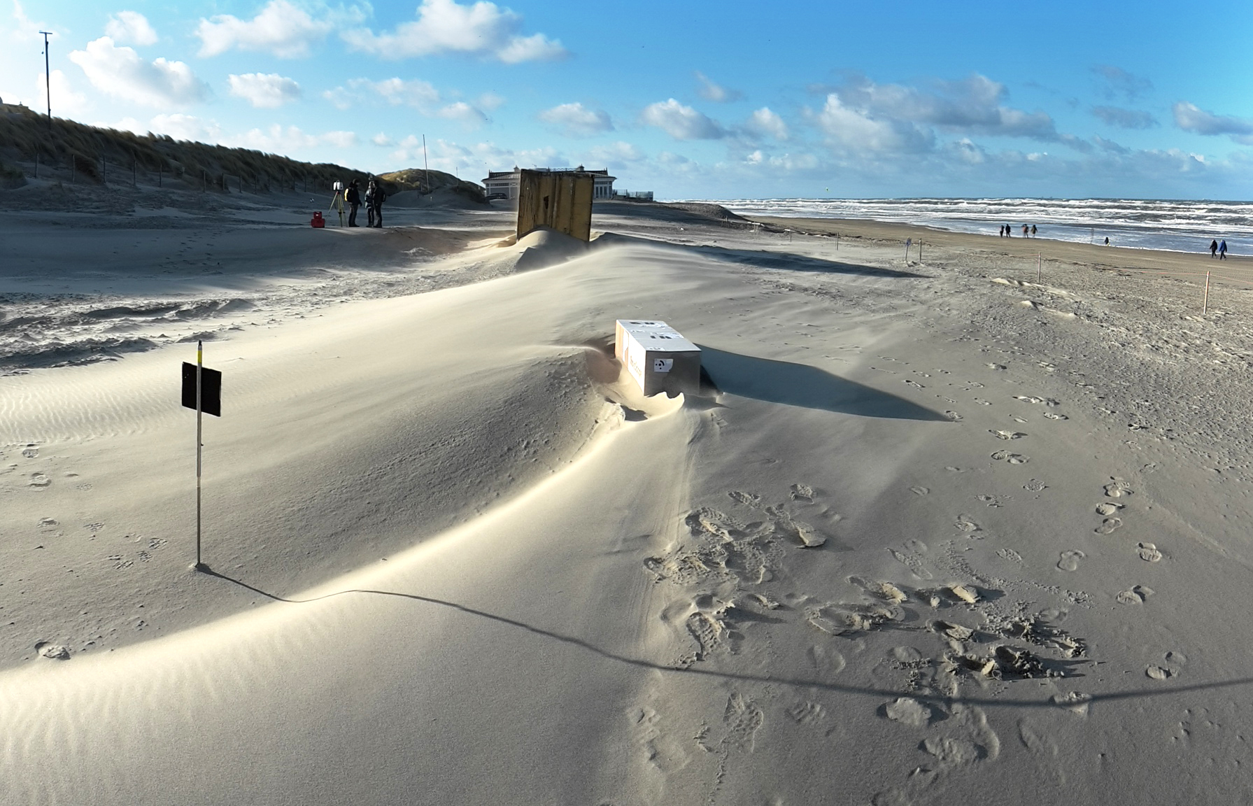
A hundred metres to the north, a section of beach next to the dunes has been cordoned off. It’s only just possible to recognise the TU Delft logo on the weather-beaten sign. In spring and summer, a sailing club moors its boats here. There is now a rusty container in the middle of the site. On the windward side, the wind has opened up a large space beneath the steel colossus. In the lee of the wind, there is a long, elevated trail of fine sand.
“We’re also measuring the effect of obstacles on the beach”, explains Vos. “There are countless beach bars along the entire coast. These hold back some of the sand heading towards the dunes. This container is being used to mimic the effect of that kind of building.”
The collection of data is scheduled for completion by 1 April. The sailing enthusiasts want their base back and the beach will start to get too busy to take proper readings. Until then, the kite surfers in the surf need to watch out.
Battering waves loosen pieces of beach