
A dike that is too high trumps getting your feet wet. But in order to avoid unnecessary investments it is important to know exactly how high a dike should be. This is what hydraulic engineer Patrick Oosterlo is trying to find out. He researches the optimal dike height of the Eemshaven-Delfzijl sea dike on the shore of the eastern Wadden Sea. Why? ‘According to the government norms from 2017 this dike is four metres below the required height and has been declared unfit for purpose. We thought that four metres was quite a hike and we weren’t sure the waves would actually reach the projected height. You want to avoid unnecessary investments and dike heightening is an expensive business.’
Complex area
Precise data about the height and force of the waves is available for most of the Dutch coast but not for the area around Delfzijl, Oosterlo says. ‘The eastern Wadden Sea is a complex area and conditions there are different from the rest of the coast, mostly because of the tidal channels, nearby islands and the funnel shaped estuary. The dike is hit by oblique waves and they are relatively high despite an offshore wind. That is a set of circumstances that is almost unique.’
Advanced measuring equipment
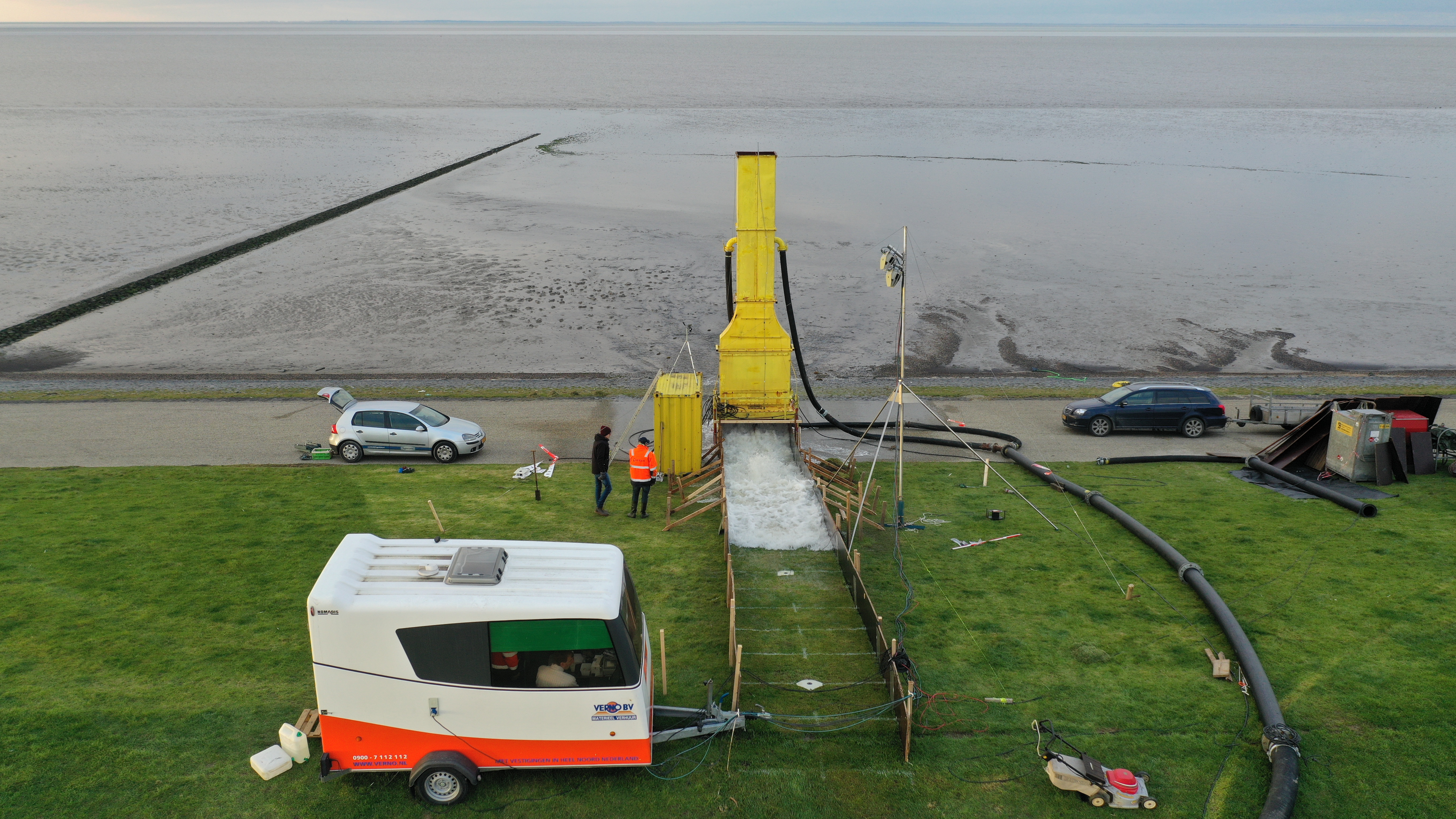
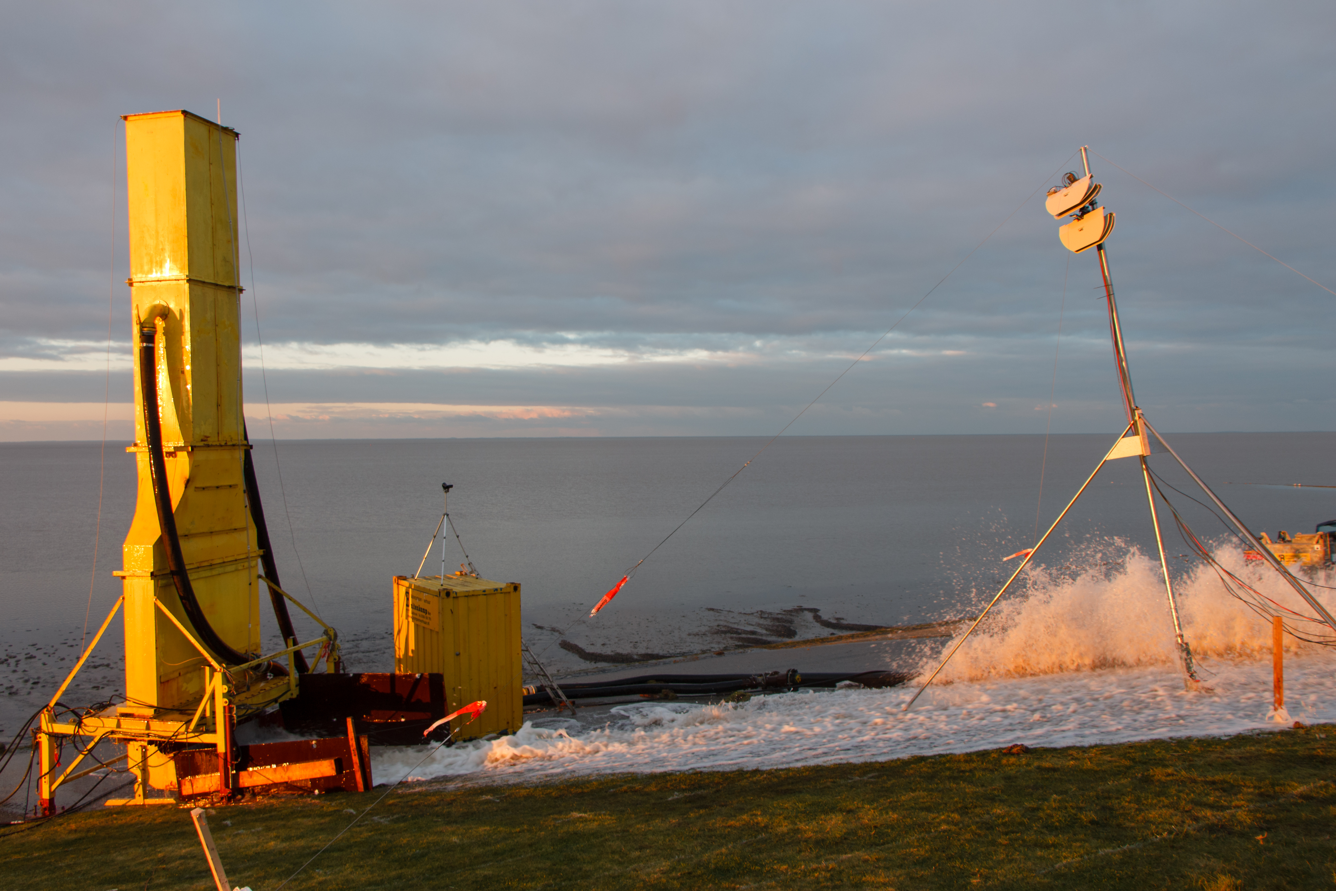
To determine optimal dike height – or the dike crest – a storm isn’t the only data input the researchers need. ‘We have been busy putting wave buoys in place along the coast, as well as with a large-scale experimental setup which simulates waves. We also put all kinds of smart measuring equipment on the dike. All these instruments are needed to find out exactly how high the waves are and with what force they hit the sea dike.
Upside down letter boxes
The experimental setup included some pretty extensive building work. ‘In two parts of the dike we built four overtopping boxes, which look like upside down letter boxes, with discharge openings in the bottom. When a wave hits the dike, the water enters the boxes. A pressure sensor measures its weight and based on this data we can ascertain how much water will theoretically overtop the crest of the dike. A measuring pole and wave buoys measure the height and direction of the incident waves,‘ Oosterlo explains.
Laser scanners on the dike
Oosterlo himself is usually to be found on the site of the laser scanners, similar to a barcode scanner but very big, which measures wave run-up on the dike surface. ‘The laser scanners emit a laser pulse onto the dike surface while the installation simulates (oblique) waves. As soon as the scanners detect a discrepancy in the distance between pulses, we know that there is water on the dike surface. The length and size of the discrepancy tells us how high the wave is, and the force with which it hits the dike. We will probably put the laser scanners in other locations as well, so we won’t have to dig to install overtopping boxes.’
Precise models
The combined data will eventually lead to more precise models to determine optimal dike heights. Oosterlo: ‘The projection period of a dike during the planning stage of regular dike segments is usually 50 years. The Noorderzijlvest water board, which is the body responsible for the management of this dike, wants to shorten this to a period of 25 years in combination with a 12-year measuring programme to gain more insights. We are now in the second year and I am currently analyzing the measuring data of the simulations and the data of a real storm in January 2019.’
Calm before the storm
This previous storm was missed by Oosterlo. ‘I had to make do with a spectacular video my supervisor made. I’d love to experience that myself some day.’ So now, Oosterlo is hoping another big storm will come along this year. ‘More data from real storms will increase the accuracy of the models. The storm season ends at the end of March and if it doesn’t happen before then we will have to wait at least until September. We will have to make do with the data gathered from the simulations and the storm of January. But I will keep a close eye on the weather reports. And if there is another storm coming you can be sure I will be there to see it. On top of the dike, preferably, tasting the fresh air.’


The following researchers are involved in this dike project:
Ir. Patrick Oosterlo (PhD-student), promotor prof. dr. ir. Jentsje van der Meer (TU Delft, IHE Delft and Van der Meer Consulting), supervisor dr. ir. Bas Hofland (TU Delft). This project was made possible by the inspiring input of late Gerbrant van Vledder. This project reflects his legacy.
The following parties are involved:
Noorderzijlvest water board, Van der Meer Consulting, Van Vledder Consulting, Infram Hydren, Arcadis, Aqua Vision, Rijkswaterstaat (Ministery of Infrastructure & the Environment), POV Waddenzeedijken, Deltares, KNMI, Groningen Seaports.


