
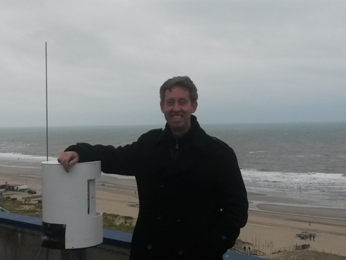
Hotel Atlantic in Kijkduin overlooks the North Sea. On its deserted roof a state of the art laser scanner is monitoring the beach every hour, 24/7. Sander Vos hopes the resulting data will provide insight into the restoration of the coast after a storm when part of the beach and fore dunes disappear into the sea. With the information provided by the scanner he and his TU Delft colleagues hope to become ‘coastal weathermen’ who will be able to predict exactly how the beach behaves after a storm.
Coastal resilience
Just how beaches are restored after a storm is not yet well known. It is an important process, however, because it maintains the coastline and keeps the dunes at a height which will protect the country from flooding. Data on coastal resilience, or the circumstances in which sand that has been washed away is blown back onto land, are few and far between. ‘Sand that has ended up in the sea because of a storm or high tide makes its way back onto the land toward the dunes when things quieten down again. In relatively dry weather and with wind force 4 to 6 the sand is dry enough to be blown from the high water mark towards the dunes,’ Sander explains.
Right place and time
The process only takes place under certain circumstances and it is not always possible to be there in time to monitor it. ‘It’s all a matter of having your equipment in the right place at the right time,’ Sanders explains. The sand moves in little layers, or so-called sediment fluxes, which are difficult to chart. With a laser scanner permanently in place it is easy to follow the processes. ‘This latest laser scanner is incredibly precise. We can monitor the movement of the sand with absolute pinpoint precision!’
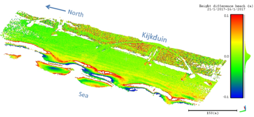
Graph 1: Kijkduin beach measurement of January 16th and 21st, 2017. The red and blue areas indicate sand deposition and erosion respectively.
Missing data
The new measurement method will provide information that has been missing in coastal monitoring so far. It will give the Dutch water authorities a tool to predict the movement of the sand with far greater precision. Now planes survey the coast each year to determine where extra sand is needed to strengthen the coast. But to gain a better understanding of coastal processes more measurements are needed. ‘An understanding of exactly how the sand is carried along the beach will tell you if you are putting the sand in the right place or if perhaps you have to reconsider that position.’ Sending up a plane every hour is not a viable option. That is the great thing about this scanner, Sander says. ‘Not only is it very precise, it’s also a relatively cheap way of getting your hands on a lot of data. It’s making the information much easier to obtain and measuring can be done much more frequently.’
Seaside visitors and beach bars
The research is still in its fundamental stage but Sander and his team hope that with time the method can be used to create better models for coastal sand movement under dry circumstances. The best result according to Sander would be if his work could contribute to appropriate measures to ensure a better use of the beach. What, for instance, is the effect of seaside visitors digging holes in the sand? And what about the beach bars at the foot of the dunes? Are they preventing the sand from accumulating in the right place? ‘These questions may possibly be answered if you have precise data such as we are collecting now. The effects of activities on the beach can be made concrete, and that could have quite a big social impact.’
But for now the laser scanner has to do its job. In a week’s time Sander can return to the hotel to collect the data. And perhaps go for a walk on the beach.
Published: March 2017
Sander Vos gained a PhD in 2002 at TU Delft under the supervision of Professor Battjes and went on to work for underwater research specialists Baars-CIPRO. In 2015 he presented his research proposal to Professor Marcel Stive and now works as a part time PostDoc / researcher at TU Delft. Vos and his colleagues are currently preparing an application for a STW grant in order to develop their measurement method and model. |


