Shape-guided artistic route finding
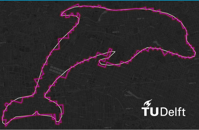
Creating GPS art on the map is an interesting way to make one’s outdoor activity more engaging. Cyclists, runners and hikers can create impressive drawings on the map by traversing the road/pedestrian network in a carefully planned way. Such planning, however, is often tedious and time consuming, which makes the GPS artists have to meticulously design the routes with the complex road network in mind. The aim of our research is to come up with a full process that can express a person’s initial idea (for example a contour drawing) as a route, which the user can then follow to create their GPS art. This involves transforming the input image to match the routing network in a selected area and generating a route which approximates the shape in the best possible way. In our work, searching for patterns in the road network is cast to an image matching problem with template matching as the solution. Generating routes is achieved using a graph routing algorithm with a custom cost function, to make the resulting route as similar to the input shape as possible. Finally, two ways of generating artistic routes are presented. First is an automatic GPS art workflow, which attempts to find an optimal initial location of the route, then generates a number of candidate routes and selects the best one according to various evaluation criteria. The second method is an interactive browser application, where the user can select an initial location for his shape on the map, move, scale or rotate it and get instant feedback in the form of artistic routes displayed in real time.
More information
- Master thesis 'Shape-guided artistic route finding'