New tool shows accessibility of public areas for different population groups
News
-
15 September 2023
What is a restaurant without its dining guests? What is a park without people walking their dog or kids playing? We are social beings and socializing is essential for our wellbeing. But how do we assess whether people from all walks of life are able to meet at these public places? This question motivated Vasileios Milias, PhD Candidate at TU Delft’s Industrial Design Engineering faculty to design a mapping tool which measures the concept of ‘co-accessibility’.
“It’s important for our health to have easy access to public spaces such as parks, public squares, and playgrounds”, Vasileios Milias explains. “But it doesn’t stop there. We want to meet our friends and interact with new people at these venues. As Jan Gehl, Danish architect and urban design consultant, once said ‘It is a fact of life that the greatest interest of people is other people’. Also, studies show that being surrounded by a mix of people has a positive effect on our health.”
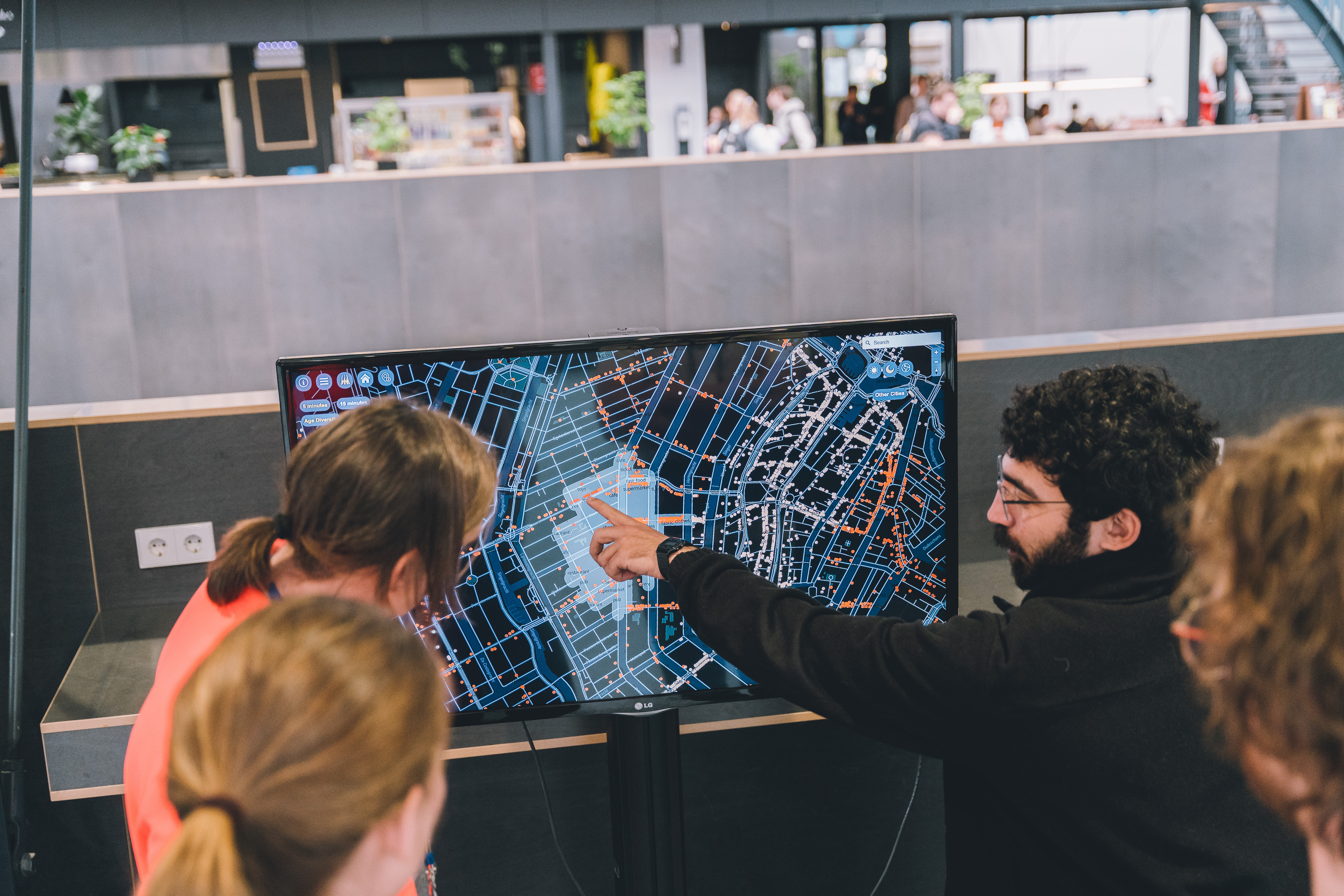
That is how Vasileios got the idea to introduce the concept of co-accessibility. “Co-accessibility indicates how accessible a given venue is to different population groups. To showcase this concept, I designed the CTwalk Map, an interactive mapping tool which can be used to measure and assess the pedestrian co-accessibility of public spaces for different age groups. The tool combines the walkable street network with public venues such as parks, museums, squares, and age demographics. All data were gathered by open sources.”
Co-accessibility indicates how accessible a given venue is to different population groups.
―
Vasileios Milias
Vasileios generated an interactive map for the five largest cities in the Netherlands: Amsterdam, Eindhoven, Rotterdam, The Hague, and Utrecht.
Discovering age group representation
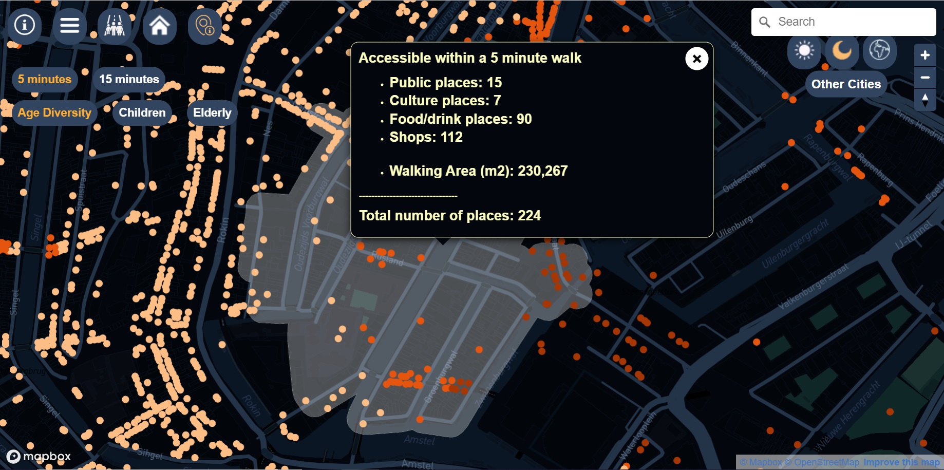
Here’s how the tool works. Go to the CTwalk Map website. Select the city you want to explore and type in your address. The map will show you the public venues you have access to within a walk of 5 or 15 minutes.
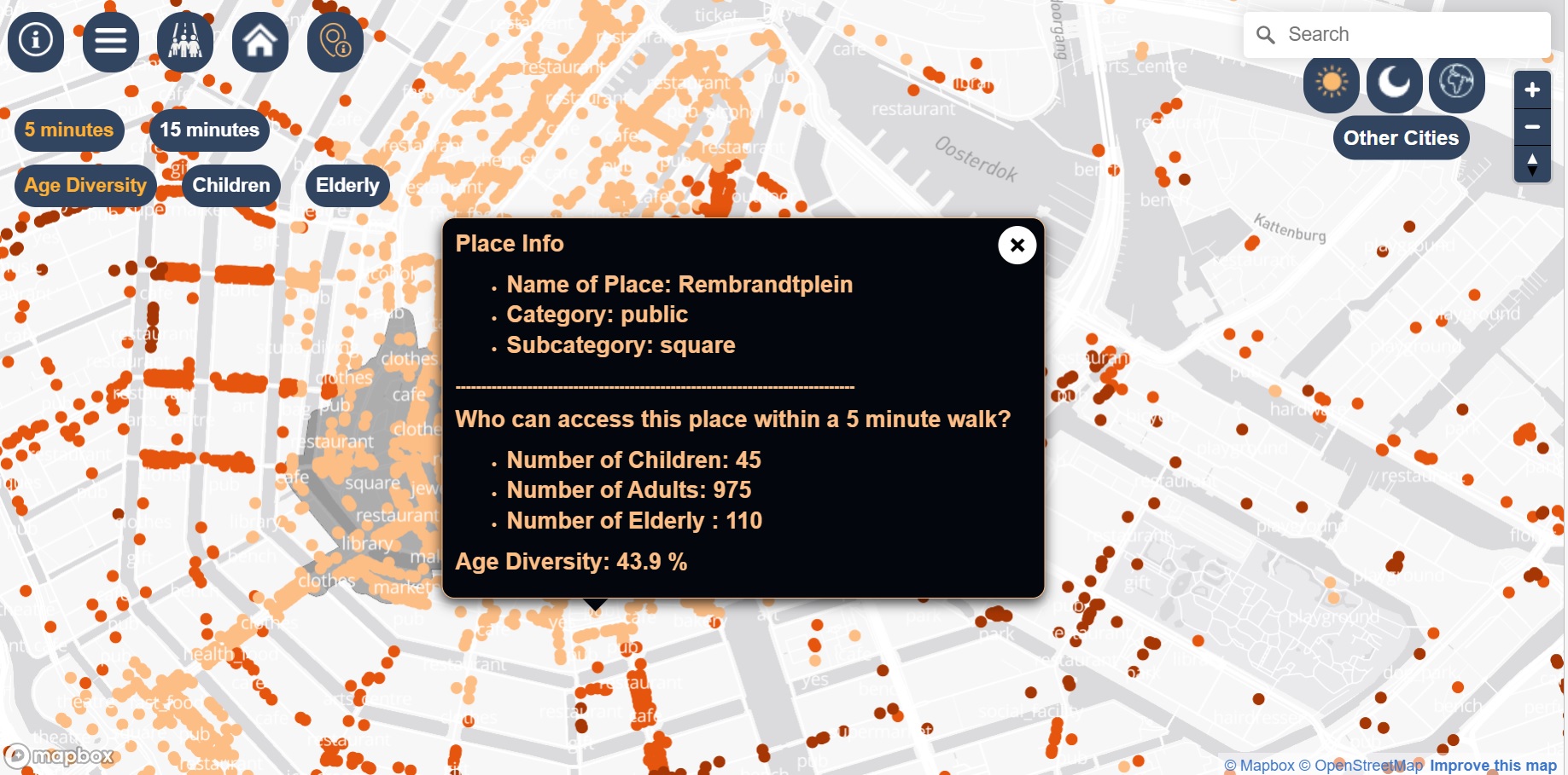
The real novelty of this tool is that you can click on any venue to gather information on its co-accessibility. Have a closer look at a nearby park for example. Simply click on its location and explore how many people have access to it within a 5 or 15-minute walk and discover which age groups are most or least represented.
“This tool could be interesting to local policymakers, city planners, and designers to fill in the gaps where co-accessibility is an issue, like an over- or underrepresentation of youngsters. They could take action to redesign a park based on who lives nearby or the street network to make the park more reachable.”
The Third Place
Why this 5 and 15-minute walking distance restriction? “A five-minute walk is feasible for a majority of people”, explains Vasileios. And you may have heard of the ’15-minute city’ plan in Paris. It is an urban planning concept in which most daily necessities and services, such as work, shopping, education, healthcare, and leisure can be easily reached by a 15-minute walk or bike ride from any point in the city. “One of the objectives of CTwalk Map is to exemplify the 15-minute city concept and to demonstrate how a mere one-minute increase or decrease in walking time can make a difference. But it is true that this parameter is not a gold standard, it is merely a reference”, admits Vasilis.
And how were the various venues selected? “My decision is influenced by Ray Oldenburg's definition of the Third Place. Where the First Place is our home, the Second Place is our job and the third is any venue where people of different ages can perform activities and socially interact with each other. That is why I chose not to include venues such as casinos or nightclubs, as children are not allowed in.”
This tool could be interesting to local policymakers, city planners, and designers to fill in the gaps where co-accessibility is an issue.
―
Vasileios Milias
The CTwalk mapping tool is not a finished product, and probably never will be. “There is great potential to add many nuances to this tool. You could incorporate the walkability of footpaths, by adding amenities such as trees, benches, streetlights to measure safety. Or you can add more socio-demographic groups, based on income or ethnicity for example”, Vasileios concludes.
Are you curious about the CTwalk Map tool and its creator? Make sure to visit the 4TU booth at Dutch Design Week from 21-29 October 2023 in Eindhoven.