REPAiR
REsource management in peri-urban areas - Going beyond urban metabolism
The core objective of REPAiR is to provide local and regional authorities with an innovative transdisciplinary open source geodesign decision support environment (GDSE) developed and implemented in living labs in six metropolitan areas in Europe: Amsterdam, Naples, Hamburg Ghent, Pécs, Łódź. The GDSE allows creating integrated, place-based eco-innovative spatial development strategies aiming at a quantitative reduction of waste flows in the strategic interface of peri-urban areas. These strategies will promote the use of waste as a resource, thus support the on-going initiatives of the European Commission towards establishing a strong circular economy.
The key challenge for REPAiR is to integrate models and methods from, among others, the environmental sciences, geographic sciences and economic sciences with design and spatial planning methods, both on a software and process level.The integrated models and methods enable local and regional stakeholders to use the geodesign decision support environment (GDSE) within a workshop setting to develop fast and reliable alternatives for spatial sustainable development strategies.
The main objective of REPAiR is to demonstrate the feasibility and validity of the GDSE as a tool for enhancing waste and resource management. To successfully develop, test and implement the GDSE, the following project objectives have been defined:
- To provide decision-makers with comparative assessments of different integrated spatial resource management strategies by combining forecasting methods, strategy conceptualisations and an integrated assessment of economic, environmental and social sustainability in a collaborative decision support environment.
- To develop an understanding of the characteristics, mechanisms and dynamics of European resource management systems by analysing the relations between waste flows, environmental and spatial quality, allocation and governance in six peri-urban areas using life cycle thinking.
- To better interpret the link between metabolic flows and urban processes, by extending the assessment of urban metabolism to include urban driver concepts and urban patterns, as well as environmental and spatial quality, and co-benefits.
- To improve the knowledge and reliability of waste-related data by activity based spatial material flow analyses.
- To implement living labs in peri-urban areas across Europe to develop, test, implement and assess place-specific eco-innovative solutions for resource management to improve environmental and spatial quality and quality of life.
- To understand decision making structures and processes in the case study areas with regard to interests and priorities of different stakeholders to add transparency to the decision-making process.
- To develop a framework for transferring (a) the key modules of the GDSE itself; and, (b) the solutions and change models that it will produce across differentiated peri-urban areas.
- To disseminate and ensure the further uptake of the project’s insights on aspects of resource management and GDSE development by including local and regional planning authorities, NGOs, public and private waste management companies, and future urban planners in the project. Moreover, open dissemination of insights, tools and technologies is provided across Europe, establishing the foundation for knowledge-based consultancy services that support local implementation of policies and spatial investments aimed at developing a circular economy.
First results
The first phase of the project was dedicated to understanding, the territory, people, waste management status quo, circular economy state and visions as well as the different governance landscapes of, predominantly, the two main pilot cases, Naples and Amsterdam. The first phase resulted in the definition of the system boundaries, the selection of the resource scopes for the case studies, the first assessment of data availability and the list of key priorities in the pilot cases. In parallel the organisation of the peri-urban living labs (PULLs), the project webpage, the dissemination plan and the data management plan were established.
Moreover, methods, for the six models have been developed. These were, among others, an integrated socio-spatial and physiological analyses, which includes an activity-based spatial materials flow analysis in order to understand and represent the extended urban metabolism of the case study areas. A framework for a multi-size (micro, meso, macro), multi-geo-scale (processes located at different geographical scales) and multidisciplinary (social, economic, or environmentally oriented) impact assessment, as well as methods for decision making during the process of the PULLs. Furthermore, methods to co-create eco-innovative solutions have been developed. Regarding the latter, a first set has been developed. This allowed to start working on methods for knowledge transfer of such eco-innovative solutions. In close collaboration the technical development of the GDSE was started.
Progress beyond the state of the art
The progress beyond state of the art during the first period of the project was predominantly related to the development of analytical methods, as well as the technical development of the GDSE.
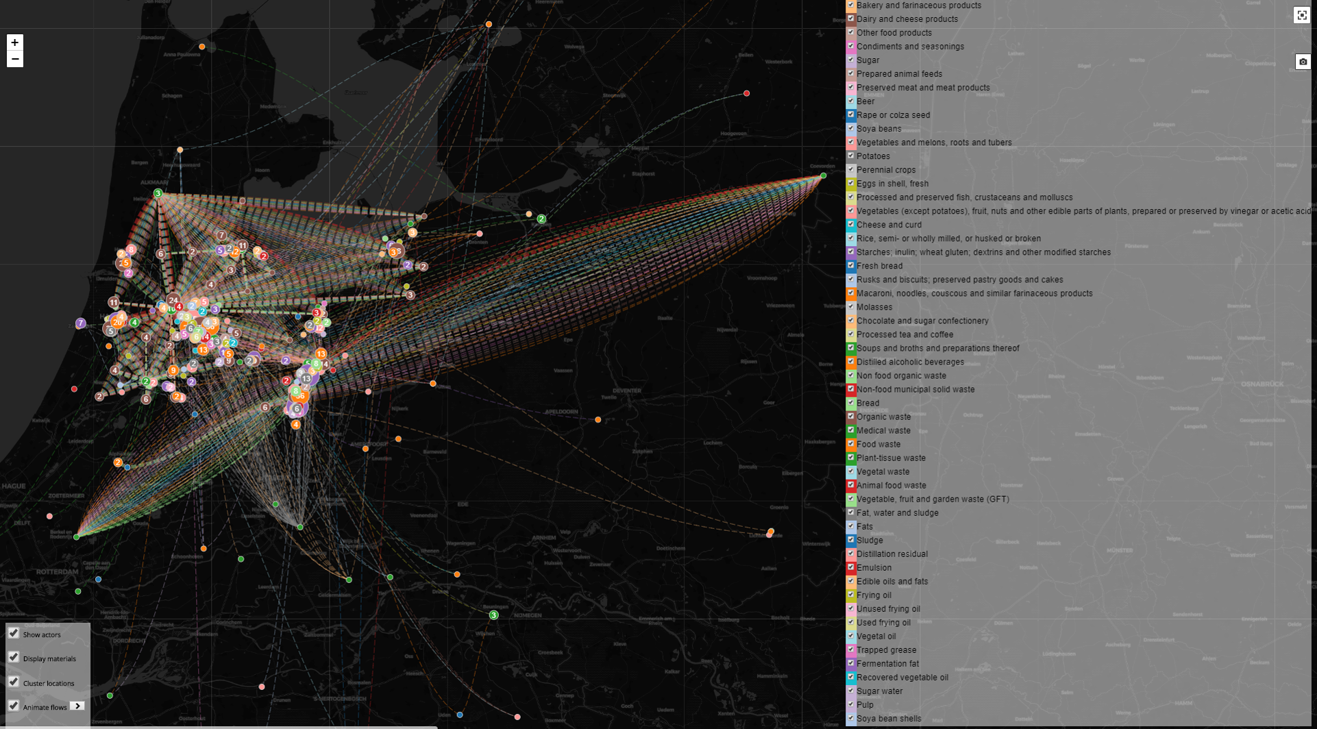
REPAiR developed the first geodesign software that includes flows, other than traffic and water. In order to do so, modules for data entry and visualisation that include waste and resource flows had to be developed.
To further extend the concept of urban metabolism and make it applicable to support development of place based eco-innovative solutions, REPAiR developed an activity-based material flow analysis (AS-MFA), which follows the so called ‘network model of urban metabolism’ and includes, activities and value chains.
REPAiR explored, through interviews, questionnaires and the co-exploration phase of the PULLs the roles of governance settings and territorial and socio-cultural characteristics of different (peri-) urban areas. Next, these were taken as factors, which constrain or support the capacity to devise place-tailored solutions to promote the use of waste as a resource.
The AS-MFA was applied in an integrated socio-spatial analysis together with further developed understanding and mapping of wastescapes to define the so called ‘enabling contexts’, which are locations or subsystems within the area of interest that are specifically suitable for developing and implementing eco-innovative solutions.
In order to be to be able to assess eco-innovative solutions a sustainability framework was developed, that is holistic and comprehensive in the sense that it covers social, economic and environmental aspects, and considers local to global impacts, based on a life cycle perspective.
The REPAiR project was used as a pilot to test a better integration of research and design education in two Urbanism Master courses: (1) MSc course “Spatial Strategies for the Global Metropolis”, an obligatory annual course of the MSc Urbanism programme that integrated CE in 2017 and 2018, each with about 75 students; (2) MSc course “Geodesign for a Circular Economy in Urban Regions”, an elective course open to students of different MSc programmes that ran in 2017 and 2018, each with about 15 students form the Architecture, Urbansim and Industrial Ecology tracks.
Facts
| Funder: | EU |
| Programme: | H2020-EU.3.5.4. - Enabling the transition towards a green economy and society through eco-innovation |
| Overall budget: | € 5.089.636 |
| Grant amount: | € 5.089.636 Contribution to TU Delft: € 1.200.000 |
| Grant number: | 688920 |
| Role TU Delft: | Lead partner |
| Project duration: | September 2016 - September 2020 |
| TU Delft researchers: | Prof.dr. Arjan van Timmeren DI. Alexander Wandl Dr. Marcin Dabrowski Bob Geldermans Hilde Remøy Erwin Heurkens Rusnė Šilerytė Cecilia Furlan Yan Song Dr. Libera Amenta |
Project partners
Delft University of Technology, Ghent University, University of Naples Federico II, HafenCity Universität Hamburg, Institute for Regional Studies, Institute of Geography and Spatial Organization - Polish Academy of Sciences, Joint Research Centre, Geo-Col GIS and Collaborative Planning, Delta Development Group, BIOKOM Nonprofit Ltd, Gertz Gutsche Rümenapp Stadtentwicklung und Mobilität, OVAM - Public Waste Agency of Flanders, Municipality of Haarlemmermeer, Campania Regional Authority, Pheno horizon, Bauer Umwelt GmbH, IVAGO, Stadtreinigung Hamburg